Breakforth Evangelical Ministery
Breakforth Evangelical Ministery is a church in Oldham, England which is located on Eldon Precinct. Breakforth Evangelical Ministery is situated nearby to the health club Fit Bodz Gym, as well as near the community center The Primrose Centre.| Tap on a place to explore it |
- Type: Church
- Denomination: Evangelical
- Address: 8-9 Eldon Precinct, Oldham, OL8 1JP
Places of Interest Nearby
Highlights include Our Lady of Mount Carmel and St Patrick Church and Gallery Oldham.
Our Lady of Mount Carmel and St Patrick Church
Church
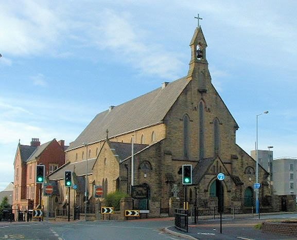
Photo: Wikimedia, CC BY-SA 2.0 uk.
Our Lady of Mount Carmel and St Patrick Church or St Patrick's Church is a Roman Catholic Parish church in Oldham, Greater Manchester, England. It was founded in 1858 and was built in 1870. Our Lady of Mount Carmel and St Patrick Church is situated 1,400 feet northwest of Breakforth Evangelical Ministery.
Gallery Oldham
Art gallery

Photo: SMJ, CC BY-SA 2.0.
Gallery Oldham is a free-to-view public museum and art gallery in the Cultural Quarter of central Oldham, in Greater Manchester, England. Gallery Oldham is situated 2,000 feet northeast of Breakforth Evangelical Ministery.
Alexandra Park
Park

Photo: Wikimedia, CC BY-SA 2.0.
Alexandra Park is a public park in Oldham, Greater Manchester, England. It was created in response to the Lancashire Cotton Famine of 1861–1865 as an attempt to keep local textile workers employed. Alexandra Park is situated 2,500 feet east of Breakforth Evangelical Ministery.
Places in the Area
Nearby places include Coppice and Oldham.
Coppice
Suburb
Coppice is a locality and urban/suburban area the town of Oldham, in Greater Manchester, England. It is located to the south of Oldham town centre and is contiguous with other areas of Oldham including Hathershaw, Werneth, Hollins, Copster Hill and Primrose Bank.
Oldham

Photo: Parrot of Doom, CC BY-SA 3.0.
Oldham is a former textile town in Greater Manchester, 7 miles northeast of city centre in the foothills of the Pennines. The main reason to visit is to explore the villages and valleys leading into the Pennines. In 2011 the population was over 96,000.
Werneth
Suburb

Photo: Alexander P Kapp, CC BY-SA 2.0.
Werneth is an area of Oldham, Greater Manchester, England. The population at the 2011 census was 12,348. It is 1 mile west-southwest of Oldham's commercial centre and one of its most ancient localities.
Breakforth Evangelical Ministery
- Categories: place of worship and religion
- Location: Oldham, England, United Kingdom, Britain and Ireland, Europe
- View on OpenStreetMap
Latitude
53.53589° or 53° 32′ 9″ northLongitude
-2.11518° or 2° 6′ 55″ westOpen location code
9C5VGVPM+9WOpenStreetMap ID
node 10565850761OpenStreetMap feature
amenity=place_of_worshipOpenStreetMap attribute
denomination=evangelical
This page is based on OpenStreetMap, Wikidata, and Wikimedia Commons.
We’d love your help improving our open data sources. Thank you for contributing.
Satellite Map
Discover Breakforth Evangelical Ministery from above in high-definition satellite imagery.
Notable Places Nearby
Highlights include Fit Bodz Gym and The Primrose Centre.
Nearby Places
Explore places such as Nashta and Betfred.
England: Must-Visit Destinations
Delve into London, Manchester, Sheffield, and Leeds.
Curious Churches to Discover
Uncover intriguing churches from every corner of the globe.
About Mapcarta. Data © OpenStreetMap contributors and available under the Open Database License". Text is available under the CC BY-SA 4.0 license, except for photos, directions, and the map. Photo: sidibousaid, CC BY 2.0.