Oxford War Memorial
Oxford War Memorial is a First World War memorial in Oxford, at the north end of St Giles', on the junction where the road splits into the A4144 Woodstock Road and the A4165 Banbury Road.| Tap on a place to explore it |
- Type: Memorial
- Description: war memorial in Oxford, Oxfordshire, England, UK
- Inscription: “IN / MEMORY / OF / THOSE WHO / FOUGHT AND / THOSE WHO / FELL / 1914–1918. AND / 1939–1945. AND ALL OTHERS WHO HAVE GIVEN THEIR LIVES / IN THE SERVICE OF THEIR COUNTRY”
Places of Interest Nearby
Highlights include Somerville College and St John’s College.
Somerville College
University
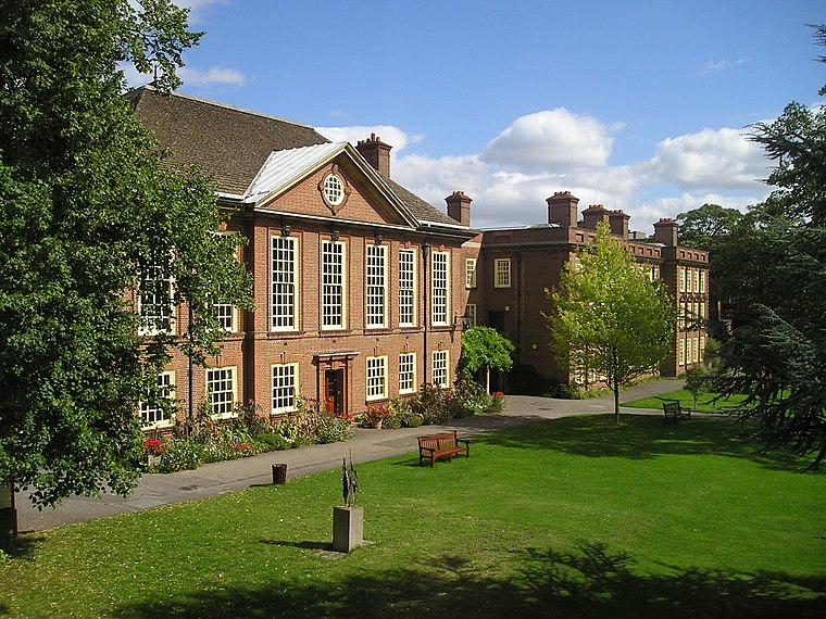
Photo: Wikimedia, CC BY-SA 3.0.
Somerville College is a constituent college of the University of Oxford in England. It was founded in 1879 as Somerville Hall, one of its first two women's colleges. Somerville College is situated 660 feet northwest of Oxford War Memorial.
St John’s College
University

Photo: Roger Davies, CC BY-SA 2.0.
St John's College is a constituent college of the University of Oxford. Founded as a men's college in 1555, it has been coeducational since 1979. Its founder, Sir Thomas White, intended to provide a source of educated Roman Catholic clerics to support the Counter-Reformation under Queen Mary. St John’s College is situated 700 feet southeast of Oxford War Memorial.
Keble College
University

Photo: Godot13, CC BY-SA 4.0.
Keble College is one of the constituent colleges of the University of Oxford in England. Its main buildings are on Parks Road, opposite the University Museum and the University Parks. Keble College is situated 510 feet east of Oxford War Memorial.
Places in the Area
Nearby places include Jericho and Oxford.
Jericho
Suburb

Photo: Wikimedia, Public domain.
Jericho is a historic suburb of the English city of Oxford. It consists of the streets bounded by the Oxford Canal, Worcester College, Walton Street and Walton Well Road.
Oxford

Photo: Diliff, CC BY-SA 3.0.
Oxford is the oldest university city in the United Kingdom, some 50 miles to the west of the capital London in its own county of Oxfordshire, on the rivers Thames and Cherwell.
Norham Manor
Quarter

Photo: Jpbowen, CC BY-SA 3.0.
The Norham Manor estate is a residential suburb in Oxford, England. It is part of central North Oxford. To the north is Park Town with its crescents, to the east is the River Cherwell, to the south are the University Parks and to the west is Walton Manor, on the other side of Banbury Road.
Oxford War Memorial
- Categories: war memorial and historic site
- Location: Oxford, Oxfordshire, South East England, England, United Kingdom, Britain and Ireland, Europe
- View on OpenStreetMap
Latitude
51.75832° or 51° 45′ 30″ northLongitude
-1.26013° or 1° 15′ 37″ westOpen location code
9C3WQP5Q+8WOpenStreetMap ID
node 1057697027OpenStreetMap feature
historic=memorialWikidata ID
Q66478189
This page is based on OpenStreetMap, Wikidata, Wikimedia Commons, and Wikipedia.
We’d love your help improving our open data sources. Thank you for contributing.
Satellite Map
Discover Oxford War Memorial from above in high-definition satellite imagery.
Notable Places Nearby
Highlights include The Barn and Department of Statistics.
Nearby Places
Explore places such as St Giles Church and Alumni House.
Oxfordshire: Must-Visit Destinations
Delve into Oxford, Abingdon-on-Thames, Banbury, and Woodstock.
Curious Memorials to Discover
Uncover intriguing memorials from every corner of the globe.
About Mapcarta. Data © OpenStreetMap contributors and available under the Open Database License". Text is available under the CC BY-SA 4.0 license, except for photos, directions, and the map. Description text is based on the Wikipedia page “Oxford War Memorial”. Photo: Mertbiol, CC0.