CCRT 22 Mile
CCRT 22 Mile is in Barnstable County, Massachusetts. CCRT 22 Mile is situated nearby to LeCount Trailhead, as well as near the tourism office Wellfleet Information.| Tap on a place to explore it |
Places of Interest Nearby
Highlights include Pond Hill School and Marconi Beach.
Pond Hill School
School building
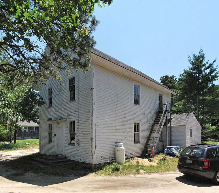
Photo: MattWade, CC BY-SA 3.0.
The Pond Hill School is a historic school building at 65 Old Paine Hollow Road in Wellfleet, Massachusetts. Built in 1857, it is the last of Wellfleet's 19th-century district schools to be built, and to survive relatively intact. Pond Hill School is situated 3,000 feet west of CCRT 22 Mile.
Marconi Beach
Beach
Marconi Beach is part of the Cape Cod National Seashore in Wellfleet, Massachusetts. The beach is named for Italian inventor Guglielmo Marconi. In 1903, the first transatlantic wireless communication originating in the United States was successfully transmitted from nearby Marconi Station; a message from U.S. President Theodore Roosevelt to King Edward VII of the United Kingdom. Marconi Beach is situated 2 miles southeast of CCRT 22 Mile.
Audubon Bird Sanctuary
Nature reserve
Wellfleet Bay Wildlife Sanctuary is a 1,183 acres wildlife sanctuary located in Wellfleet, Massachusetts, on Cape Cod. The sanctuary was established by the Massachusetts Audubon Society in 1957. Audubon Bird Sanctuary is situated 2½ miles south of CCRT 22 Mile.
Places in the Area
Nearby places include Wellfleet and North Eastham.
Wellfleet

Photo: MattWade, CC BY-SA 3.0.
Wellfleet is in Massachusetts on Cape Cod and includes the village of South Wellfleet. Its name is believed to be derived from "whale fleet". A quaint rural feel exists to Wellfleet.
North Eastham
Hamlet
 North Eastham is a census-designated place in the town of Eastham in Barnstable County, Massachusetts, United States. The population was 1,806 at the 2010 census. North Eastham is situated 3½ miles south of CCRT 22 Mile.
Eastham
 Eastham is a town of 5,800 people in Massachusetts on Cape Cod, and includes the village of North Eastham. Eastham is home to some beautiful bay and ocean beaches, most notably Coast Guard Beach and Nauset Lighthouse Beach, as well as several fresh water kettle ponds.
CCRT 22 Mile
- Type: Sign
- Categories: information and tourism
- Location: Barnstable County, Massachusetts, New England, United States, North America
- View on OpenStreetMap
Latitude
41.9158° or 41° 54′ 57″ northLongitude
-69.98745° or 69° 59′ 15″ westOpen location code
87HGW287+82OpenStreetMap ID
node 11082429915OpenStreetMap feature
tourism=information
This page is based on OpenStreetMap, Wikidata, and Wikimedia Commons.
We’d love your help improving our open data sources. Thank you for contributing.
Satellite Map
Discover CCRT 22 Mile from above in high-definition satellite imagery.
Notable Places Nearby
Highlights include LeCount Trailhead and Wellfleet Information.
Nearby Places
Explore places such as Blackfish Creek and Cape Cod Rail Trail - Welcome.
Massachusetts: Must-Visit Destinations
Delve into Boston, Cambridge, Springfield, and Downtown Boston.
Curious Places to Discover
Uncover intriguing places from every corner of the globe.
About Mapcarta. Data © OpenStreetMap contributors and available under the Open Database License". Text is available under the CC BY-SA 4.0 license, except for photos, directions, and the map. Photo: papadunes, CC BY-SA 3.0.