Politiepost Loenen
Politiepost Loenen is a police station in Apeldoorn, Veluwe, Gelderland which is located on Loenerdrift. Politiepost Loenen is situated nearby to the community center De Bruisbeek, as well as near the art gallery Galerie ‘t Arthuus.| Tap on a place to explore it |
- Opening hours: Thursday 5:00 PM—6:00 PM
- Type: Police station
- Address: Loenerdrift 80, Loenen, 7371CM
Places of Interest Nearby
Highlights include Station Loenen and De Middelste Molen, Loenen.
Station Loenen
Railway station
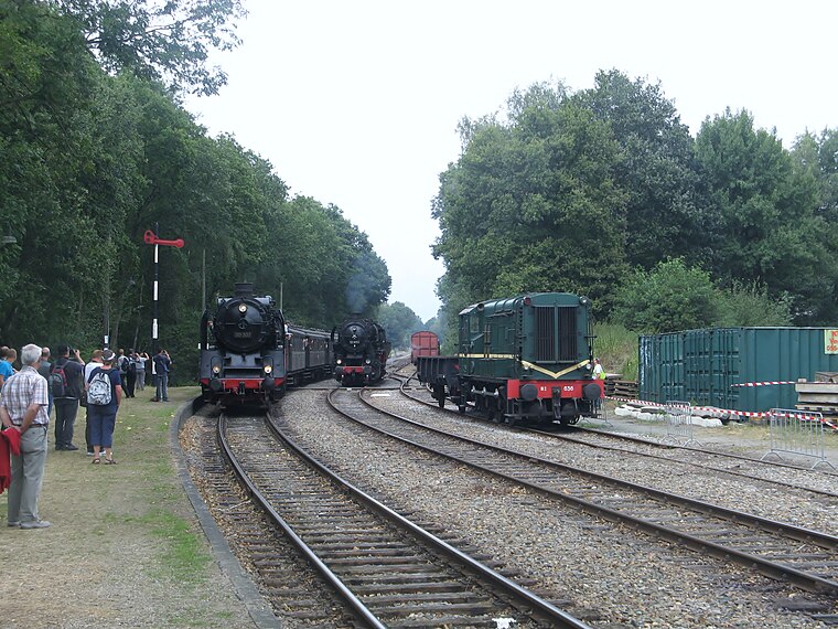
Photo: CrabbyPatrick, CC BY 3.0.
Station Loenen is a railway station, which is situated 2 km northeast of Politiepost Loenen.
De Middelste Molen, Loenen
Museum

Photo: Quistnix, CC BY-SA 2.5.
De Middelste Molen, Loenen is a museum, which is situated 2½ km northeast of Politiepost Loenen.
Huis Ter Horst
House
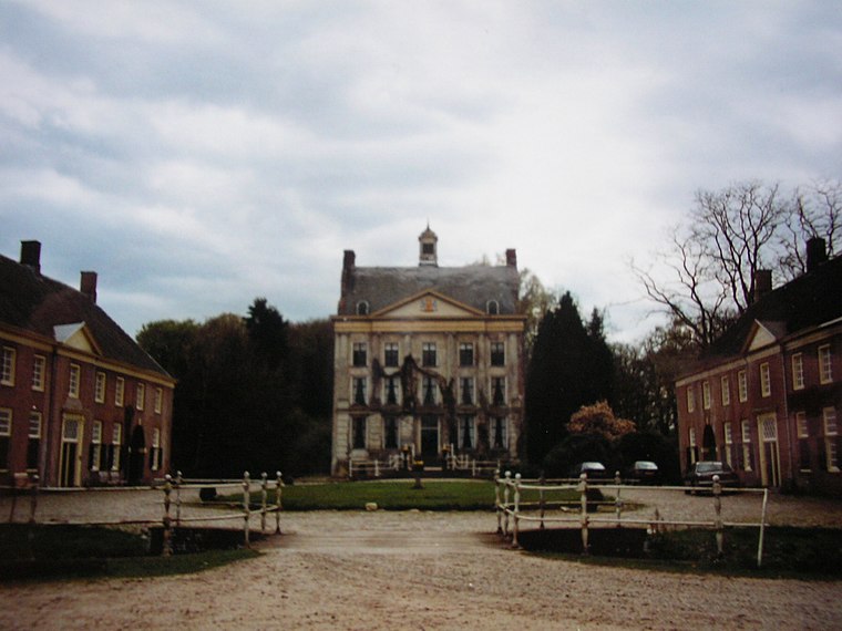
Photo: Gijsevers, CC BY-SA 3.0.
Huis Ter Horst is a house, which is situated 1½ km northeast of Politiepost Loenen.
Places in the Area
Nearby places include Loenen and Eerbeek.
Loenen
Village

Photo: Wikimedia, CC BY-SA 4.0.
Loenen is a village in the Dutch province of Gelderland. It is located in the municipality of Apeldoorn, about 10 km southeast of that city. Loenen was a separate municipality until 1818, when it was merged with Apeldoorn.
Eerbeek
Village
Eerbeek is a town in the municipality of Brummen in the province of Gelderland in the Netherlands. Eerbeek was first mentioned in 1046 as Erbeke. In the 18th century, Eerbeek became a centre of paper production. Eerbeek is situated 3½ km east of Politiepost Loenen.
Woeste Hoeve
Hamlet
Photo: Apdency, Public domain.
De Woeste Hoeve is a hamlet in the Netherlands between Apeldoorn and Arnhem, which is remembered for an incident in the Second World War when, during the night of 6 March 1945, Dutch resistance fighters shot the Nazi Chief of Police, SS General Hanns Rauter. Woeste Hoeve is situated 4½ km west of Politiepost Loenen.
Politiepost Loenen
- Location: Apeldoorn, Veluwe, Gelderland, Eastern Netherlands, Netherlands, Benelux, Europe
- View on OpenStreetMap
Latitude
52.11381° or 52° 6′ 50″ northLongitude
6.01861° or 6° 1′ 7″ eastOpen location code
9F484279+GCOpenStreetMap ID
node 11117720838OpenStreetMap feature
amenity=police
This page is based on OpenStreetMap, Wikidata, and Wikimedia Commons.
We’d love your help improving our open data sources. Thank you for contributing.
Satellite Map
Discover Politiepost Loenen from above in high-definition satellite imagery.
Notable Places Nearby
Highlights include De Bruisbeek and Galerie ‘t Arthuus.
Nearby Places
Explore places such as Spar Loenen and SPAR.
Veluwe: Must-Visit Destinations
Delve into Ede, Wageningen, Harderwijk, and Elburg.
Curious Police Stations to Discover
Uncover intriguing police stations from every corner of the globe.
About Mapcarta. Data © OpenStreetMap contributors and available under the Open Database License". Text is available under the CC BY-SA 4.0 license, except for photos, directions, and the map. Photo: Kleinleugenmors, CC BY-SA 3.0.