Hackbridge Convenience Store
Hackbridge Convenience Store is a convenience store in Sutton, Greater London, England. Hackbridge Convenience Store is situated nearby to Hackbridge Post Office, as well as near Hackbridge Christian Spiritualist Church.| Tap on a place to explore it |
Places of Interest Nearby
Highlights include Hackbridge railway station and BedZED.
Hackbridge railway station
Railway station

Photo: Sunil060902, CC BY-SA 3.0.
Hackbridge railway station is a railway station at Hackbridge in the London Borough of Sutton in South London. The station is served by Southern and Thameslink. Hackbridge railway station is situated 600 feet southeast of Hackbridge Convenience Store.
BedZED

Photo: Tom Chance, CC BY 2.0.
Beddington Zero Energy Development is an environmentally friendly housing development in Hackbridge, London, England. It is in the London Borough of Sutton, 2 miles north-east of the town of Sutton itself. BedZED is situated 1,100 feet north of Hackbridge Convenience Store.
All Saints
Church

Photo: Robin Webster, CC BY-SA 2.0.
All Saints is a church, which is situated 1,300 feet northwest of Hackbridge Convenience Store.
Places in the Area
Nearby places include Hackbridge and Carshalton.
Hackbridge
Suburb
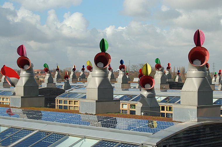
Photo: Tom Chance, CC BY-SA 2.0.
Hackbridge is a suburb in the London Borough of Sutton, south-west London, just over two miles north-east of the town of Sutton itself. It is 8.8 miles south-west of Charing Cross.
Carshalton
Town

Photo: Rodge500, CC BY-SA 2.5.
Carshalton is a town, with a historic village centre, in south London, England, within the London Borough of Sutton. It is situated around 9.5 miles southwest of Charing Cross and around 1.3 miles east by north of Sutton town centre, in the valley of the River Wandle, one of the sources of which is Carshalton Ponds in the south of the village.
Beddington
Suburb

Photo: Kemal ATLI, CC BY-SA 2.0.
Beddington is a suburban settlement in the London Borough of Sutton on the boundary with the London Borough of Croydon. Beddington is formed from a village of the same name which until early the 20th century still included land which became termed entirely as Wallington.
Hackbridge Convenience Store
- Type: Convenience store
- Categories: shop and food
- Location: Sutton, Greater London, England, United Kingdom, Britain and Ireland, Europe
- View on OpenStreetMap
Latitude
51.37934° or 51° 22′ 46″ northLongitude
-0.1553° or 0° 9′ 19″ westOpen location code
9C3X9RHV+PVOpenStreetMap ID
node 11174677130OpenStreetMap feature
shop=convenience
This page is based on OpenStreetMap, Wikidata, and Wikimedia Commons.
We’d love your help improving our open data sources. Thank you for contributing.
Satellite Map
Discover Hackbridge Convenience Store from above in high-definition satellite imagery.
Notable Places Nearby
Highlights include Hackbridge Post Office and Hackbridge Christian Spiritualist Church.
Nearby Places
Explore places such as Asia Tandoori and All Tile Ceramics & Bathrooms Ltd.
England: Must-Visit Destinations
Delve into London, Manchester, Sheffield, and Leeds.
Curious Convenience Stores to Discover
Uncover intriguing convenience stores from every corner of the globe.
About Mapcarta. Data © OpenStreetMap contributors and available under the Open Database License". Text is available under the CC BY-SA 4.0 license, except for photos, directions, and the map. Photo: sidibousaid, CC BY 2.0.