Hudson/Innes
Hudson/Innes is a railway stop in San Francisco, Bay Area, California. Hudson/Innes is situated nearby to Saint Johns Missionary Baptist Church, as well as near the reservoir Cistern at 3rd & Kirkwood.| Tap on a place to explore it |
Places of Interest Nearby
Highlights include Hudson/Innes station and Kirkwood/La Salle station.
Hudson/Innes station
Railway station

Photo: Pi.1415926535, CC BY-SA 3.0.
Hudson/Innes station is a light rail station on the Muni Metro T Third Street line in the Bayview neighborhood of San Francisco, California. The station opened with the T Third Street line on January 13, 2007.
Kirkwood/La Salle station
Railway station
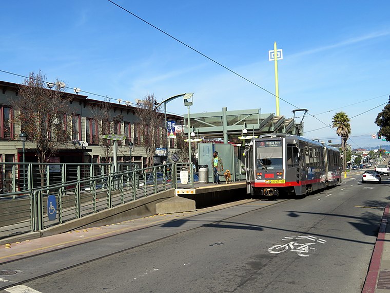
Photo: Pi.1415926535, CC BY-SA 3.0.
Kirkwood/La Salle station is a light rail station on the Muni Metro T Third Street line in the Bayview neighborhood of San Francisco, California. The station opened with the T Third Street line on January 13, 2007. Kirkwood/La Salle station is situated 1,000 feet south of Hudson/Innes.
Evans station
Railway station

Photo: Pi.1415926535, CC BY-SA 3.0.
Evans station is a light rail station on the Muni Metro T Third Street line, located in the median of 3rd Street at Evans Avenue in the Bayview neighborhood of San Francisco, California. Evans station is situated 970 feet north of Hudson/Innes.
Places in the Area
Nearby places include Silver Terrace and Alemany Maze.
Silver Terrace
Neighborhood
Silver Terrace is a neighborhood in the south eastern corner of San Francisco, between Bayview–Hunters Point and Portola neighborhoods. It is roughly bordered by Third Street to the east, Palou Avenue and Silver Avenue to the north, Williams Avenue to the south and Bayshore Boulevard and U.S. Route 101 to the west.
Alemany Maze
Locality
The Alemany Maze is an interchange between the James Lick Freeway and the John F. Foran Freeway in the city of San Francisco. Alternative names for this highway feature are Alemany Interchange and The Spaghetti Bowl.
Southeast San Francisco

Photo: Eric Fredericks, CC BY-SA 2.0.
Southeast San Francisco is made up of several mostly residential neighborhoods of San Francisco bounded on the north and west by I-280, the 101 highway, and 16th Street, the east by the San Francisco Bay, and on the south by the city limits.
Hudson/Innes
- Type: Railway stop
- Wheelchair access: yes
- Categories: transport stop and transportation
- Location: San Francisco, Bay Area, California, United States, North America
- View on OpenStreetMap
Latitude
37.74015° or 37° 44′ 25″ northLongitude
-122.38879° or 122° 23′ 20″ westOperator
San Francisco Municipal RailwayNetwork
MuniOpen location code
849VPJR6+3FOpenStreetMap ID
node 1130229323OpenStreetMap feature
public_transport=stop_positionOpenStreetMap feature
railway=stopOpenStreetMap attribute
wheelchair=yes
This page is based on OpenStreetMap, Wikidata, and Wikimedia Commons.
We’d love your help improving our open data sources. Thank you for contributing.
Satellite Map
Discover Hudson/Innes from above in high-definition satellite imagery.
Places with the Same Name
Discover other places named “Hudson/Innes”.
Notable Places Nearby
Highlights include Saint Johns Missionary Baptist Church and Cistern at 3rd & Kirkwood.
Nearby Places
Explore places such as 3rd Street & Hudson Avenue and Hudson Avenue & 3rd Street.
San Francisco: Must-Visit Destinations
Delve into Golden Gate, Chinatown-North Beach, Civic Center-Tenderloin, and Fisherman’s Wharf.
Curious Railway Stops to Discover
Uncover intriguing railway stops from every corner of the globe.
About Mapcarta. Data © OpenStreetMap contributors and available under the Open Database License". Text is available under the CC BY-SA 4.0 license, except for photos, directions, and the map. Photo: Wikimedia, CC BY-SA 3.0.