Skelager Skatepark
Skelager Skatepark is a pitch in Aalborg Municipality, North Jutland. Skelager Skatepark is situated nearby to the sports venue Falcon BMX, as well as near the community center Multihuset.| Tap on a place to explore it |
Places of Interest Nearby
Highlights include Mulighedernes Park and Skalborg Church.
Mulighedernes Park
Park

Photo: Zoizit, CC BY-SA 4.0.
Mulighedernes Park is situated 110 metres northwest of Skelager Skatepark.
Skalborg Church
Church

Photo: Edam66, Public domain.
Skalborg Church is situated 770 metres southeast of Skelager Skatepark.
Hasseris Gymnasium
School

Photo: Algizdk, Public domain.
Hasseris Gymnasium is a school, which is situated 600 metres northwest of Skelager Skatepark.
Places in the Area
Nearby places include Skalborg and Hasseris.
Skalborg
Suburb
Photo: Edam66, Public domain.
Skalborg is a neighbourhood in southern Aalborg, Denmark. It is located approximately 6km south of the city center. Skalborg has a population of 8,696 and an area of approximately 8 km².
Hasseris
Suburb
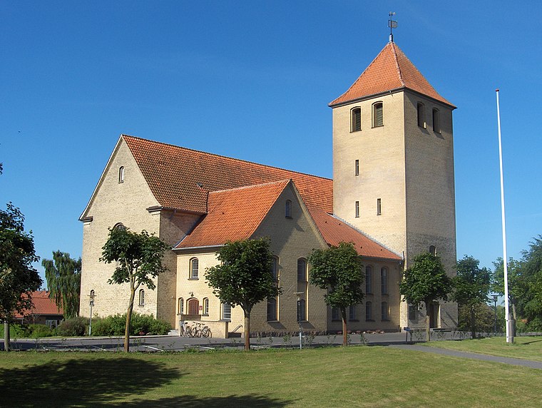
Photo: Edam66, Public domain.
Hasseris is a district of the city of Aalborg and a former municipality in the northeast of Denmark. It is located some 3 km southwest of the city centre. As of 2016, Hasseris had 11,685 inhabitants.
Eternitten
Suburb
Photo: Laketown, CC BY-SA 3.0.
Eternitten is a suburb, which is situated 3½ km northeast of Skelager Skatepark.
Skelager Skatepark
- Type: Pitch
- Categories: skateboard, recreation area, and sports location
- Location: Aalborg Municipality, North Jutland, Jutland, Denmark, Nordic countries, Europe
- View on OpenStreetMap
Latitude
57.02058° or 57° 1′ 14″ northLongitude
9.8815° or 9° 52′ 53″ eastOpen location code
9F9F2VCJ+6HOpenStreetMap ID
node 11336850730OpenStreetMap feature
leisure=pitchOpenStreetMap feature
sport=skateboard
This page is based on OpenStreetMap, Wikidata, and Wikimedia Commons.
We’d love your help improving our open data sources. Thank you for contributing.
Satellite Map
Discover Skelager Skatepark from above in high-definition satellite imagery.
Notable Places Nearby
Highlights include Falcon BMX and Multihuset.
Nearby Places
Explore places such as Ungetilbud Sofiebo and Seluxit A/S.
North Jutland: Must-Visit Destinations
Delve into Aalborg, Frederikshavn, Skagen, and Hjørring.
Curious Pitches to Discover
Uncover intriguing pitches from every corner of the globe.
About Mapcarta. Data © OpenStreetMap contributors and available under the Open Database License". Text is available under the CC BY-SA 4.0 license, except for photos, directions, and the map. Photo: Slaunger, CC BY-SA 3.0.