Eia Street
Eia Street is a bus stop in Belfast, County Antrim, Northern Ireland. Eia Street is situated nearby to Duncairn Street Post Office, as well as near the community center Church Hall.| Tap on a place to explore it |
Places of Interest Nearby
Highlights include HM Prison Belfast and Solitude.
HM Prison Belfast
Museum
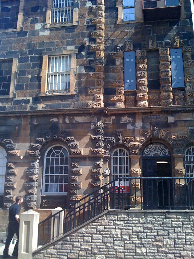
Photo: Agadant, CC BY-SA 3.0.
HM Prison Belfast, also known as Crumlin Road Gaol, is a former prison situated on the Crumlin Road in north Belfast, Northern Ireland. Since 1996 it is the only remaining Victorian era former prison in Northern Ireland. HM Prison Belfast is situated 2,400 feet southwest of Eia Street.
Solitude
Pitch
 Solitude is a football stadium in north Belfast, Northern Ireland. Home ground of Ireland's oldest football club, Cliftonville, it is the oldest football stadium in Ireland. Solitude is situated 2,500 feet northwest of Eia Street.
Mater Infirmorum Hospital
Hospital
The Mater Infirmorum Hospital, commonly known as The Mater, is an acute hospital in Belfast, Northern Ireland. It provides services to most of North Belfast and South Antrim, reaching as far as Glengormley, Carrickfergus and Newtownabbey It is managed by the Belfast Health and Social Care Trust. Mater Infirmorum Hospital is situated 2,500 feet south of Eia Street.
Places in the Area
Nearby places include New Lodge and Cathedral Quarter.
New Lodge
Suburb

Photo: Gerry Lynch, CC BY 2.5.
The New Lodge is an urban, working class Catholic community in Belfast, Northern Ireland, immediately to the north of the city centre. The landscape is dominated by several large tower blocks.
Cathedral Quarter
Quarter

Photo: Stuart, CC BY-SA 2.0.
The Cathedral Quarter in Belfast, Northern Ireland, is a developing area of the city, roughly situated between Royal Avenue near where the Belfast Central Library building is, and the Dunbar Link in the city centre.
Titanic Quarter
Quarter

Photo: Wikimedia, CC BY-SA 4.0.
Titanic Quarter in Belfast, Northern Ireland, is a large-scale waterfront regeneration, comprising historic maritime landmarks, film studios, education facilities, apartments, a riverside entertainment district, and the world's largest Titanic-themed attraction centred on land in Belfast Harbour, known until 1995 as Queen's Island, and initially, Dargan's Island.
Eia Street
- Type: Bus stop
- Category: transportation
- Location: Belfast, County Antrim, Northern Ireland, United Kingdom, Britain and Ireland, Europe
- View on OpenStreetMap
Latitude
54.61557° or 54° 36′ 56″ northLongitude
-5.93753° or 5° 56′ 15″ westOperator
Translink MetroNetwork
MetroOpen location code
9C6PJ386+6XOpenStreetMap ID
node 11342304872OpenStreetMap feature
highway=bus_stopOpenStreetMap feature
public_transport=platform
This page is based on OpenStreetMap, Wikidata, and Wikimedia Commons.
We’d love your help improving our open data sources. Thank you for contributing.
Satellite Map
Discover Eia Street from above in high-definition satellite imagery.
Notable Places Nearby
Highlights include Duncairn Street Post Office and Church Hall.
Nearby Places
Explore places such as Eia Street and Roccos.
County Antrim: Must-Visit Destinations
Delve into Giant’s Causeway, Lisburn, Ballymena, and Larne.
Curious Bus Stops to Discover
Uncover intriguing bus stops from every corner of the globe.
About Mapcarta. Data © OpenStreetMap contributors and available under the Open Database License". Text is available under the CC BY-SA 4.0 license, except for photos, directions, and the map. Photo: AlasdairW, CC BY-SA 3.0.