The Salvation Army - Bury
The Salvation Army - Bury is a church in Metropolitan Borough of Bury, England which is located on Brookshaw Street. The Salvation Army - Bury is situated nearby to Freedom Church, as well as near the garden The Top Green.| Tap on a place to explore it |
- Email: bury@salvationarmy.org.uk
- Type: Church
- Denomination: Salvation Army
- Address: 18 Brookshaw Street, Bury, BL9 6EB
Places of Interest Nearby
Highlights include Clarence Park and Bury Transport Museum.
Clarence Park
Park

Photo: David Dixon, CC BY-SA 2.0.
Clarence Park is a Green Flag awarded public park located in Bury, Greater Manchester. It is the largest urban park in the borough, and was opened to the public in 1888. Clarence Park is situated 1,800 feet north of The Salvation Army - Bury.
Bury Transport Museum
Museum
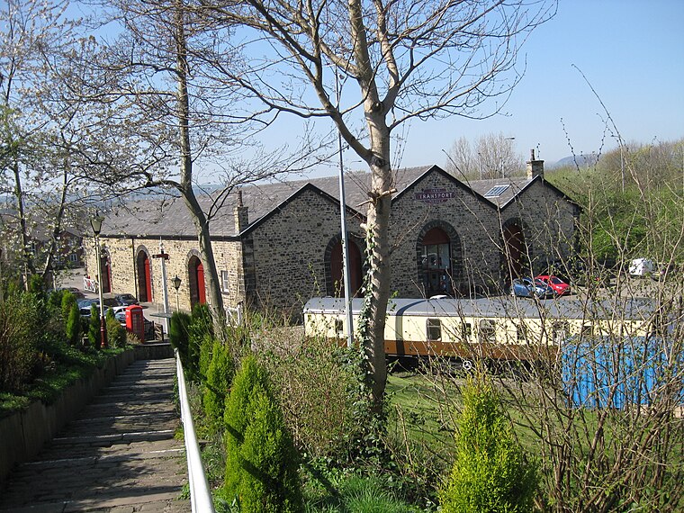
Photo: Chemical Engineer, CC BY-SA 4.0.
Bury Transport Museum is a transport museum in Bury, Greater Manchester, situated in the former Castlecroft Goods Warehouse, a Grade II listed building from 1846, on Castlecroft Road, with the main entrance from Bolton Street, BL9 0EY. Bury Transport Museum is situated 3,500 feet southwest of The Salvation Army - Bury.
Fusilier Museum
Museum

Photo: David Dixon, CC BY-SA 2.0.
The Fusilier Museum is a museum in Bury, Greater Manchester, England. Its collection includes the uniforms, medal and artefacts of the Lancashire Fusiliers. Fusilier Museum is situated 3,800 feet southwest of The Salvation Army - Bury.
Places in the Area
Nearby places include Bury and Birtle.
Bury

Photo: jolmartyn, CC BY-SA 3.0.
Bury is a town and borough in Greater Manchester, in the North West of England, ten miles north of central Manchester. Bury is a former mill town known for manufacturing textiles.
Birtle
Hamlet
Photo: michael ely, CC BY-SA 2.0.
Birtle is an affluent hamlet Historically in the parish of bury, Lancashire now within the Metropolitan Borough of Rochdale, in Greater Manchester, England. Birtle is situated 1½ miles northeast of The Salvation Army - Bury.
Walshaw
Village

Photo: Wikimedia, CC BY-SA 2.0.
Walshaw is a village forming part of the Metropolitan Borough of Bury, in Greater Manchester, England. It’s to the south of Tottington and 2 miles northwest of Bury. Walshaw is situated 2 miles west of The Salvation Army - Bury.
The Salvation Army - Bury
- Categories: place of worship and religion
- Location: Metropolitan Borough of Bury, England, United Kingdom, Britain and Ireland, Europe
- View on OpenStreetMap
Latitude
53.60092° or 53° 36′ 3″ northLongitude
-2.28837° or 2° 17′ 18″ westOpen location code
9C5VJP26+9MOpenStreetMap ID
node 11386514882OpenStreetMap feature
amenity=place_of_worshipOpenStreetMap attribute
denomination=salvation_army
This page is based on OpenStreetMap, Wikidata, and Wikimedia Commons.
We’d love your help improving our open data sources. Thank you for contributing.
Satellite Map
Discover The Salvation Army - Bury from above in high-definition satellite imagery.
Notable Places Nearby
Highlights include Freedom Church and The Top Green.
Nearby Places
Explore places such as Walmersley Road/Chesham Road and Walmersley Road/Cateaton Street.
England: Must-Visit Destinations
Delve into London, Manchester, Sheffield, and Leeds.
Curious Churches to Discover
Uncover intriguing churches from every corner of the globe.
About Mapcarta. Data © OpenStreetMap contributors and available under the Open Database License". Text is available under the CC BY-SA 4.0 license, except for photos, directions, and the map. Photo: sidibousaid, CC BY 2.0.