Teenage Dreams So Hard To Beat
Teenage Dreams So Hard To Beat is a work of art in Belfast, County Antrim, Northern Ireland. Teenage Dreams So Hard To Beat is situated nearby to the community center Doyle Youth Club, as well as near the theme park PJ Land.| Tap on a place to explore it |
Places of Interest Nearby
Highlights include Odyssey and Titanic Quarter railway station.
Odyssey

Photo: Ross, CC BY-SA 2.0.
The Odyssey, consisting of the Odyssey Place, W5 and the SSE Arena, is a sports, entertainment and science learning complex located within the Titanic Quarter in Belfast, Northern Ireland. Odyssey is situated 1,400 feet northwest of Teenage Dreams So Hard To Beat.
Titanic Quarter railway station
Railway station

Photo: Aubrey Dale, CC BY-SA 2.0.
Titanic Quarter railway station is located in the townland of Ballymacarrett in east Belfast, Northern Ireland. It is a short walk from the SSE Arena and Titanic Quarter. Titanic Quarter railway station is situated 1,000 feet northeast of Teenage Dreams So Hard To Beat.
SS Nomadic
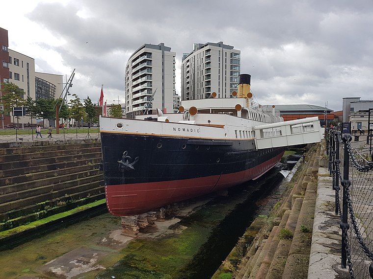
Photo: Irid Escent, CC BY-SA 2.0.
SS Nomadic is a former tender of the White Star Line, launched on 25 April 1911 at Belfast, that is now on display in Belfast's Titanic Quarter. She was built to transfer passengers and mail to and from the ocean liners RMS Olympic and RMS Titanic. SS Nomadic is situated 2,100 feet north of Teenage Dreams So Hard To Beat.
Places in the Area
Nearby places include Titanic Quarter and Cathedral Quarter.
Titanic Quarter
Quarter

Photo: Wikimedia, CC BY-SA 4.0.
Titanic Quarter in Belfast, Northern Ireland, is a large-scale waterfront regeneration, comprising historic maritime landmarks, film studios, education facilities, apartments, a riverside entertainment district, and the world's largest Titanic-themed attraction centred on land in Belfast Harbour, known until 1995 as Queen's Island, and initially, Dargan's Island.
Cathedral Quarter
Quarter

Photo: Stuart, CC BY-SA 2.0.
The Cathedral Quarter in Belfast, Northern Ireland, is a developing area of the city, roughly situated between Royal Avenue near where the Belfast Central Library building is, and the Dunbar Link in the city centre.
Linen Quarter
Quarter

Photo: Wikimedia, Public domain.
The Linen Quarter is an area of Belfast, Northern Ireland. The name is derived from the great many linen warehouses that are still present in the area.
Teenage Dreams So Hard To Beat
- Type: Work of art
- Artwork type: mural
- Category: tourism
- Location: Belfast, County Antrim, Northern Ireland, United Kingdom, Britain and Ireland, Europe
- View on OpenStreetMap
Latitude
54.60062° or 54° 36′ 2″ northLongitude
-5.91076° or 5° 54′ 39″ westOpen location code
9C6PJ32Q+6MOpenStreetMap ID
node 11627771527OpenStreetMap feature
tourism=artworkOpenStreetMap attribute
artwork_type=mural
This page is based on OpenStreetMap, Wikidata, and Wikimedia Commons.
We’d love your help improving our open data sources. Thank you for contributing.
Satellite Map
Discover Teenage Dreams So Hard To Beat from above in high-definition satellite imagery.
Notable Places Nearby
Highlights include Doyle Youth Club and PJ Land.
Nearby Places
Explore places such as Eastside Park and Ride and City East Business Centre.
County Antrim: Must-Visit Destinations
Delve into Giant’s Causeway, Lisburn, Ballymena, and Larne.
Curious Work Of Arts to Discover
Uncover intriguing work of arts from every corner of the globe.
About Mapcarta. Data © OpenStreetMap contributors and available under the Open Database License". Text is available under the CC BY-SA 4.0 license, except for photos, directions, and the map. Photo: AlasdairW, CC BY-SA 3.0.