Entfaltungsraum Trier e.V.
Entfaltungsraum Trier e.V. is a community center in Trier, Moselle Valley, Rhineland-Palatinate. Entfaltungsraum Trier e.V. is situated nearby to the playground Spielplatz Auf der Ayl, as well as near the winery Weingut Terges.| Tap on a place to explore it |
Places of Interest Nearby
Highlights include Blesius Garten and Aula Palatina.
Blesius Garten
Hotel

Photo: Mattes, CC BY-SA 2.0.
Blesius Garten is a hotel, which is situated 180 metres west of Entfaltungsraum Trier e.V..
Aula Palatina
Church
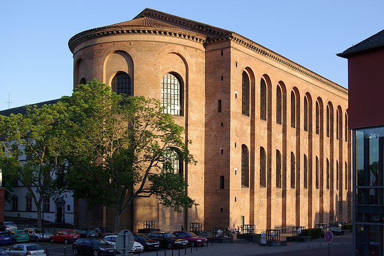
Photo: Berthold Werner, Public domain.
The Aula Palatina, also called Basilica of Constantine, at Trier, Germany, is a Roman palace basilica and an early Christian structure built between AD 300 and 310 during the reigns of Constantius Chlorus and Constantine the Great. Aula Palatina is situated 2 km northwest of Entfaltungsraum Trier e.V..
Trier Imperial Baths
Archaeological site

Photo: Berthold Werner, Public domain.
The Trier Imperial Baths are a large Roman bath complex in Trier, Germany. The complex was constructed in the early 4th century AD, during the reign of Constantine I. Trier Imperial Baths is situated 1½ km northwest of Entfaltungsraum Trier e.V..
Places in the Area
Nearby places include Kernscheid and Korlingen.
Kernscheid
Suburb

Photo: Wolkenkratzer, CC BY-SA 4.0.
Kernscheid is a suburb, which is situated 2½ km southeast of Entfaltungsraum Trier e.V..
Korlingen
Village

Photo: Wikimedia, CC BY-SA 3.0.
Korlingen is a municipality in the Trier-Saarburg district, in Rhineland-Palatinate, Germany. Korlingen is situated 5 km east of Entfaltungsraum Trier e.V..
Hockweiler
Village

Photo: Tomukas, CC BY-SA 4.0.
Hockweiler is a municipality in the Trier-Saarburg district, in Rhineland-Palatinate, Germany. Hockweiler is situated 5 km southeast of Entfaltungsraum Trier e.V..
Entfaltungsraum Trier e.V.
- Email: entfaltungsraum-trier@web.de
- Type: Community center
- Location: Trier, Moselle Valley, Rhineland-Palatinate, Germany, Central Europe, Europe
- View on OpenStreetMap
Latitude
49.74309° or 49° 44′ 35″ northLongitude
6.6624° or 6° 39′ 45″ eastOpen location code
8FX8PMV6+6XOpenStreetMap ID
node 11678897663OpenStreetMap feature
amenity=community_centre
This page is based on OpenStreetMap, Wikidata, and Wikimedia Commons.
We’d love your help improving our open data sources. Thank you for contributing.
Satellite Map
Discover Entfaltungsraum Trier e.V. from above in high-definition satellite imagery.
Notable Places Nearby
Highlights include Spielplatz Auf der Ayl and Weingut Terges.
Nearby Places
Explore places such as Walter Bach and Johanna Bach.
Moselle Valley: Must-Visit Destinations
Delve into Cochem, Konz, Traben-Trarbach, and Treis-Karden.
Curious Community Centers to Discover
Uncover intriguing community centers from every corner of the globe.
About Mapcarta. Data © OpenStreetMap contributors and available under the Open Database License". Text is available under the CC BY-SA 4.0 license, except for photos, directions, and the map. Photo: Wikimedia, CC0.