Club Hípico / Club Hípico
Club Hípico / Club Hípico is a bus stop in Central Santiago, Santiago province, Santiago Metropolitan. Club Hípico / Club Hípico is situated nearby to the hackspace Hackerspace Santiago, as well as near the arts center Centro Cultural Argot.| Tap on a place to explore it |
Places of Interest Nearby
Highlights include Fantasilandia and O’Higgins Park.
Fantasilandia
Theme park

Photo: Wikimedia, CC BY-SA 4.0.
Fantasilandia is a Chilean amusement park. The park opened in 1978 and is located in a corner of O'Higgins Park in Santiago, Chile. Fantasilandia is situated 260 metres east of Club Hípico / Club Hípico.
O’Higgins Park
Park
 O'Higgins Park, covering approximately 75 hectares, is Santiago, Chile's second largest public park after Metropolitan Park. It is situated in the center of the capital city, within the Santiago Commune.
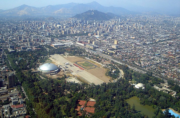
Club Hípico de Santiago
Stadium

Photo: Paul Lowry, CC BY 2.0.
Club Hípico de Santiago is a thoroughbred horse race track in Santiago, Chile. Club Hípico de Santiago is situated 560 metres southwest of Club Hípico / Club Hípico.
Places in the Area
Nearby places include Central Chile and Barrio Dieciocho.
Central Chile
 Central Chile is one of the most important regions of Chile. It is where you will find Santiago, a number of charming small towns in the Andean highlands, the largest ski resort in Chile, and important seaside ports like Valparaiso.


Club Hípico / Club Hípico
- Type: Bus stop
- Category: transportation
- Location: Central Santiago, Santiago province, Santiago Metropolitan, Chile, South America
- View on OpenStreetMap
Latitude
-33.4598° or 33° 27′ 35″ southLongitude
-70.66508° or 70° 39′ 54″ westOpen location code
47RFG8RM+3XOpenStreetMap ID
node 1175621131OpenStreetMap feature
highway=bus_stopOpenStreetMap feature
public_transport=platform
This page is based on OpenStreetMap, Wikidata, and Wikimedia Commons.
We’d love your help improving our open data sources. Thank you for contributing.
Satellite Map
Discover Club Hípico / Club Hípico from above in high-definition satellite imagery.
Notable Places Nearby
Highlights include Hackerspace Santiago and Centro Cultural Argot.
Nearby Places
Explore places such as Veterinaria Blanco and Picadelly.
Chile: Must-Visit Destinations
Delve into Central Chile, Santiago, Valparaíso, and Concepción.
Curious Bus Stops to Discover
Uncover intriguing bus stops from every corner of the globe.
About Mapcarta. Data © OpenStreetMap contributors and available under the Open Database License". Text is available under the CC BY-SA 4.0 license, except for photos, directions, and the map. Photo: Wikimedia, CC0.