pierrondins
pierrondins is an electrical substation in Dijon, Côte-d’Or, Bourgogne-Franche-Comté. pierrondins is situated nearby to the park Square Charles le Téméraire, as well as near the building Maison Constantin.| Tap on a place to explore it |
Places of Interest Nearby
Highlights include Dijon-Ville station and Église Saint Bernard de Dijon.
Dijon-Ville station
Railway station
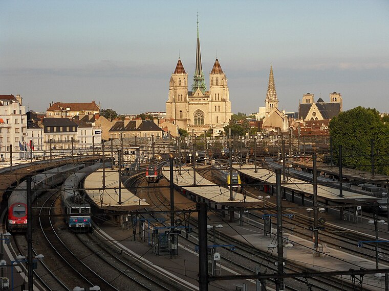
Photo: G CHP, CC BY-SA 2.5.
Dijon-Ville station, sometimes simply Dijon, is a railway station located in Dijon, Côte-d'Or, eastern France. The station was opened in 1849. It is located at the junction of Paris–Marseille, Dijon–Saint-Amour, Dijon–Is-sur-Tille, and Dijon-Vallorbe lines. Dijon-Ville station is situated 1¼ km south of pierrondins.
Église Saint Bernard de Dijon
Church

Photo: François de Dijon, CC BY-SA 4.0.
Église Saint Bernard de Dijon is a church, which is situated 680 metres southwest of pierrondins.
Musée des Beaux-Arts de Dijon
Museum

Photo: Christophe.Finot, CC BY-SA 2.5.
The Musée des Beaux-Arts de Dijon is a museum of fine arts opened in 1787, in Dijon, France. It is one of the main and oldest museums of France. It is located in the historic city centre of Dijon and housed in the former ducal palace which was the headquarters of the Burgundy State in the 15th century. Musée des Beaux-Arts de Dijon is situated 1½ km southeast of pierrondins.
Places in the Area
Nearby places include Centre-Ville and Chenôve.

Chenôve
Town

Photo: Wikimedia, CC BY-SA 4.0.
Chenôve is a commune in the Côte-d'Or department in the Bourgogne-Franche-Comté region of France. Until 1955, it was a small scale wine-growing village, when it was absorbed into the urban conglomeration of Dijon. Chenôve is situated 5 km southwest of pierrondins.
Quetigny
Town

Photo: Erkethan, CC BY-SA 3.0.
Quetigny is a commune in the Côte-d'Or department in eastern France. Quetigny is situated 7 km east of pierrondins.
pierrondins
- Type: Electrical substation
- Category: industry
- Location: Dijon, Arrondissement of Dijon, Côte-d’Or, Bourgogne-Franche-Comté, France, Europe
- View on OpenStreetMap
Latitude
47.33329° or 47° 19′ 60″ northLongitude
5.02759° or 5° 1′ 39″ eastOperator
EnedisOpen location code
8FV782MH+82OpenStreetMap ID
node 11830888344
This page is based on OpenStreetMap, Wikidata, and Wikimedia Commons.
We’d love your help improving our open data sources. Thank you for contributing.
Satellite Map
Discover pierrondins from above in high-definition satellite imagery.
Notable Places Nearby
Highlights include Square Charles le Téméraire and Maison Constantin.
Nearby Places
Explore places such as Boite à lire and Patchouli.
Côte-d’Or: Must-Visit Destinations
Delve into Beaune, Semur-en-Auxois, Aiserey, and Châtillon-sur-Seine.
Curious Electrical Substations to Discover
Uncover intriguing electrical substations from every corner of the globe.
About Mapcarta. Data © OpenStreetMap contributors and available under the Open Database License". Text is available under the CC BY-SA 4.0 license, except for photos, directions, and the map. Photo: François de Dijon, CC BY-SA 3.0.