Spannavarden
Spannavarden is a peak in Karmøy, Rogaland, Western Norway and has an elevation of 146 metres. Spannavarden is situated nearby to the neighborhood Kartmyr, as well as near the hamlet Spanne.| Tap on a place to explore it |
Places of Interest
Highlights include Oasen and Norheim Church.
Oasen
Shopping center
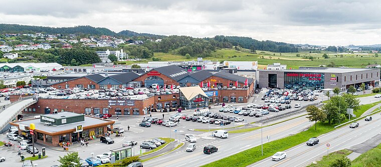
Photo: Dageinar.solberg, CC BY-SA 4.0.
Oasen Storsenter is a shopping centre in Norheim in Karmøy, Norway. In 2014 it had a turnover of 688 million Norwegian kroner. It has 65 stores in 33,000 m2 of building space. In addition to this there are 28 services within health and well-being.
Norheim Church
Church

Photo: Vinguru, CC BY-SA 4.0.
Norheim Church is a parish church of the Church of Norway in Karmøy Municipality in Rogaland county, Norway. It is located in the village of Norheim, just south of the town of Haugesund.
Rossabø Church
Church
 Rossabø Church is a parish church of the Church of Norway in Haugesund Municipality in Rogaland county, Norway. It is located in the southern part of the town of Haugesund.
Places in the Area
Nearby places include Haugesund and Avaldsnes.
Haugesund

Photo: Wikimedia, CC BY-SA 3.0.
Haugesund is a city in the county of Rogaland, in the West Norway region of Norway. The town offers a much wider range of goods and services than might be expected from a city of its size, due to its position as the definite centre of its relatively populous region.
Avaldsnes
Village

Photo: Johan Christian Dahl, Public domain.
Avaldsnes is a village in Karmøy municipality in Rogaland county, Norway. The village is located on the northeastern part of the island of Karmøy, along the Karmsundet strait, just south of the town of Haugesund.
Norheim
Village

Photo: Btd, CC BY-SA 2.5.
Norheim is a village in Karmøy municipality in Rogaland county, Norway. The village is located along the Karmsundet strait immediately south of the town of Haugesund, just over the municipal border inside Karmøy.
Spannavarden
- Type: Peak with an elevation of 146 metres
- Category: landform
- Location: Karmøy, Rogaland, Western Norway, Norway, Nordic countries, Europe
- View on OpenStreetMap
Latitude
59.3783° or 59° 22′ 42″ northLongitude
5.3407° or 5° 20′ 27″ eastElevation
146 metres (479 feet)Open location code
9FF798HR+87OpenStreetMap ID
node 11830966591OpenStreetMap feature
natural=peak
This page is based on OpenStreetMap, Wikidata, and Wikimedia Commons.
We’d love your help improving our open data sources. Thank you for contributing.
Satellite Map
Discover Spannavarden from above in high-definition satellite imagery.
Localities in the Area
Explore places such as Kartmyr and Spanne.
Notable Places Nearby
Highlights include Tronefjellet and Arareil.
Rogaland: Must-Visit Destinations
Delve into Stavanger, Haugesund, Sandnes, and Forsand.
Curious Peaks to Discover
Uncover intriguing peaks from every corner of the globe.
About Mapcarta. Data © OpenStreetMap contributors and available under the Open Database License". Text is available under the CC BY-SA 4.0 license, except for photos, directions, and the map. Photo: Ritchyblack, CC BY-SA 3.0.