Gorton Library
Gorton Library is a library in Manchester, England which is located on Garratt Way. Gorton Library is situated nearby to the community center Gorton Hub, as well as near Gorton Police Station.| Tap on a place to explore it |
- Opening hours:
Monday: 10:00 AM—5:00 PM
Tuesday: 1:00 PM—8:00 PM
Wednesday: closed
Thursday: 10:00 AM—8:00 PM
Friday: 10:00 AM—1:00 PM
Saturday: 10:00 AM—5:00 PM
Sunday: closed - Type: Library
- Address: 27 Garratt Way, Manchester, M18 8HE
Places of Interest Nearby
Highlights include Belle Vue railway station and Ryder Brow railway station.
Belle Vue railway station
Railway station
 Belle Vue railway station serves the area of Belle Vue, Manchester, England. It is a stop on the Hope Valley line for services between Manchester Piccadilly and New Mills Central. Belle Vue railway station is situated 1,000 feet west of Gorton Library.
Ryder Brow railway station
Railway station

Photo: Keith Williamson, CC BY-SA 2.0.
Ryder Brow railway station serves the Gorton and Ryder Brow areas of Manchester, England. It was opened in 1985 by British Rail as a stop on the Hope Valley Line; the station is located 2+3⁄4 miles south-east of Manchester Piccadilly. Ryder Brow railway station is situated 1,800 feet south of Gorton Library.
Brookfield Unitarian Church
Church

Photo: Gerald England, CC BY-SA 2.0.
Brookfield Unitarian Church, Gorton, Manchester, England is a Victorian Gothic church. It is a member of the General Assembly of Unitarian and Free Christian Churches, the umbrella body for British Unitarians. Brookfield Unitarian Church is situated 1,700 feet southeast of Gorton Library.
Places in the Area
Nearby places include Belle Vue and Openshaw.
Belle Vue
Suburb

Photo: KGGucwa, CC BY-SA 3.0.
Belle Vue is an area of Manchester, England, sited east of the city centre; it is bordered by the Hope Valley Line to the east and the Glossop line to the west. It is part of the electoral ward of Longsight.
Openshaw
Suburb

Photo: Rept0n1x, CC BY-SA 3.0.
Openshaw is a suburb of Manchester, Greater Manchester, England, about three miles east of the Manchester city centre. Historically part of Lancashire, Openshaw was incorporated into the city of Manchester in 1890.
Longsight
Suburb
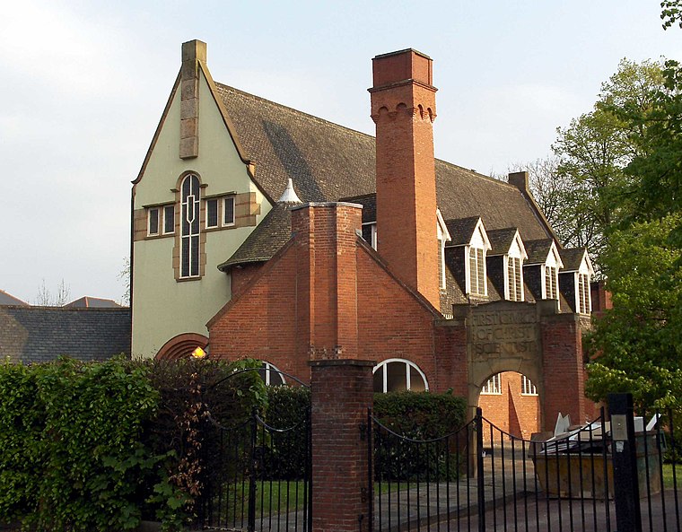
Photo: Stemonitis, CC BY 2.5.
Longsight is an inner city area of Manchester, England, 3 miles south of the city centre, bounded by Ardwick and West Gorton to the north and east; Levenshulme to the south; and Chorlton-on-Medlock, Victoria Park and Fallowfield to the west.
Gorton Library
- Category: education
- Location: Manchester, England, United Kingdom, Britain and Ireland, Europe
- View on OpenStreetMap
Latitude
53.46181° or 53° 27′ 43″ northLongitude
-2.17547° or 2° 10′ 32″ westOpen location code
9C5VFR6F+PROpenStreetMap ID
node 11832927076OpenStreetMap feature
amenity=library
This page is based on OpenStreetMap, Wikidata, and Wikimedia Commons.
We’d love your help improving our open data sources. Thank you for contributing.
Satellite Map
Discover Gorton Library from above in high-definition satellite imagery.
Notable Places Nearby
Highlights include Gorton Hub and Gorton Police Station.
Nearby Places
Explore places such as Gorton, Hyde Road / near Whitwell Way and Jobcentre Plus.
Manchester: Must-Visit Destinations
Delve into Manchester Airport, Victoria-Shopping District, Piccadilly-East Centre, and Castlefield-Petersfield.
Curious Libraries to Discover
Uncover intriguing libraries from every corner of the globe.
About Mapcarta. Data © OpenStreetMap contributors and available under the Open Database License". Text is available under the CC BY-SA 4.0 license, except for photos, directions, and the map. Photo: David Dixon, CC BY-SA 2.0.