Gloucester Lock
Gloucester Lock is a memorial in Gloucester District, Gloucestershire, England. Gloucester Lock is situated nearby to Lock Warehouse, as well as near the town hall North Warehouse.| Tap on a place to explore it |
Places of Interest Nearby
Highlights include North Warehouse and HM Prison Gloucester.
North Warehouse
Town hall

Photo: Ian Capper, CC BY-SA 2.0.
North Warehouse is a British warehouse in the Gloucester Docks. Currently, it houses the Gloucester City Council.
HM Prison Gloucester
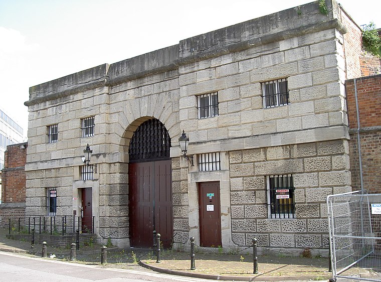
Photo: Neil Owen, CC BY-SA 2.0.
HM Prison Gloucester was a Category B men's prison located in Gloucester, Gloucestershire, England. It was originally opened in 1792, on the site of Gloucester Castle whose keep had been used as a prison. HM Prison Gloucester is situated 410 feet northeast of Gloucester Lock.
Gloucester Cathedral
Church

Photo: Wikimedia, CC BY-SA 4.0.
Gloucester Cathedral, formally the Cathedral Church of St Peter and the Holy and Indivisible Trinity and formerly St Peter's Abbey, in Gloucester, England, stands in the north of the city near the River Severn. Gloucester Cathedral is situated 1,700 feet northeast of Gloucester Lock.
Places in the Area
Nearby places include Gloucester and Over.
Gloucester

Photo: Traveler100, CC BY-SA 4.0.
Gloucester is the county town of Gloucestershire in England's West Country. A major attraction of the city is Gloucester Cathedral, which is the burial place of King Edward II.
Over
Suburb

Photo: Alby, CC BY-SA 2.0.
Over is a village in Gloucestershire, England, 2 mi west of Gloucester. It lies on the A40 road in the parish of Highnam, on the west bank of the River Severn.
Walham
Hamlet
Walham is a hamlet in Longford parish, north of Gloucester, England. It lies on the banks of the River Severn and north of the A40 road. It is a suburb of Gloucester, which is to its south.
Gloucester Lock
- Type: Memorial
- Category: historic site
- Location: Gloucester District, Gloucestershire, West Country, England, United Kingdom, Britain and Ireland, Europe
- View on OpenStreetMap
Latitude
51.86433° or 51° 51′ 52″ northLongitude
-2.25252° or 2° 15′ 9″ westOpen location code
9C3VVP7W+PXOpenStreetMap ID
node 12135695510OpenStreetMap feature
historic=memorial
This page is based on OpenStreetMap, Wikidata, and Wikimedia Commons.
We’d love your help improving our open data sources. Thank you for contributing.
Satellite Map
Discover Gloucester Lock from above in high-definition satellite imagery.
Notable Places Nearby
Highlights include Lock Warehouse and The Naight.
Nearby Places
Explore places such as DeliGreek and Historic Gloucester Docks.
Gloucestershire: Must-Visit Destinations
Delve into Gloucester, Cheltenham, Cirencester, and Yate.
Curious Memorials to Discover
Uncover intriguing memorials from every corner of the globe.
About Mapcarta. Data © OpenStreetMap contributors and available under the Open Database License". Text is available under the CC BY-SA 4.0 license, except for photos, directions, and the map. Photo: Matthew Hartley, CC BY-SA 2.0.