Wilson Parking
Wilson Parking is a parking area in Melbourne, Victoria. Wilson Parking is situated nearby to the government office Australian Medical Centre National Test Centre, as well as near the building Argus Centre.| Tap on a place to explore it |
Places of Interest Nearby
Highlights include Melbourne Central and State Library of Victoria.
Melbourne Central
Shopping center
Melbourne Central is a large shopping centre, office and public transport hub in the Melbourne central business district. It is located on the corner of La Trobe Street and Swanston Street. Melbourne Central is situated 220 metres east of Wilson Parking.
State Library of Victoria
Library

Photo: Donaldytong, Public domain.
State Library Victoria is the state library of Victoria, Australia. Located in Melbourne, it was established in 1854 as the Melbourne Public Library, making it Australia's oldest public library and one of the first free libraries in the world. State Library of Victoria is situated 460 metres east of Wilson Parking.
Coop’s Shot Tower
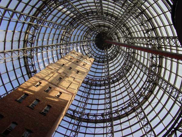
Photo: Canley, CC BY-SA 3.0.
Coop's Shot Tower is a shot tower located in the heart of the Melbourne CBD, Australia. It was completed in 1889 and is 50 metres high. The historic building was saved from demolition in 1973 and was incorporated into Melbourne Central complex in 1991 underneath an 84 m-high conical glass roof. Coop’s Shot Tower is situated 250 metres east of Wilson Parking.
Places in the Area
Nearby places include CBD and Melbourne.
CBD

Photo: Wikimedia, CC BY-SA 3.0.
The central business district of Melbourne is the city's cultural, entertainment and financial heart. Locally called the CBD, or simply "the City", it is where most international and interstate visitors spend the bulk of their time.
Melbourne

Photo: Scott Cresswell, CC BY 2.0.
Melbourne is Australia's cultural capital and second biggest city, with Victorian-era architecture, extensive shopping, museums, galleries, theatres, and large parks and gardens.
Chinatown
Neighborhood

Photo: Sgroey, CC BY-SA 4.0.
Chinatown is an ethnic enclave in the central business district of Melbourne, Victoria, Australia. Centred at the eastern end of Little Bourke Street, it extends between the corners of Swanston and Spring streets, and consists of numerous laneways, alleys and arcades.
Wilson Parking
- Type: Parking area
- Parking: multi-storey
- Category: transportation
- Location: Melbourne, Victoria, Australia, Oceania
- View on OpenStreetMap
Latitude
-37.81032° or 37° 48′ 37″ southLongitude
144.96031° or 144° 57′ 37″ eastBrand
Wilson ParkingOperator
Wilson ParkingOpen location code
4RJ65XQ6+V4OpenStreetMap ID
node 12259550887OpenStreetMap feature
amenity=parkingOpenStreetMap attribute
parking=multi-storey
This page is based on OpenStreetMap, Wikidata, and Wikimedia Commons.
We’d love your help improving our open data sources. Thank you for contributing.
Satellite Map
Discover Wilson Parking from above in high-definition satellite imagery.
Places with the Same Name
Discover other places named “Wilson Parking”.
Notable Places Nearby
Highlights include Australian Medical Centre National Test Centre and Argus Centre.
Nearby Places
Explore places such as Scape and Two Pillars.
Victoria: Must-Visit Destinations
Delve into Melbourne, CBD, Geelong, and Ballarat.
Curious Parking Areas to Discover
Uncover intriguing parking areas from every corner of the globe.
About Mapcarta. Data © OpenStreetMap contributors and available under the Open Database License". Text is available under the CC BY-SA 4.0 license, except for photos, directions, and the map. Photo: Ricmik, CC BY-SA 3.0.