Pinar de los Ingleses
Pinar de los Ingleses is a locality in Valladolid, Castile and León. Pinar de los Ingleses is situated nearby to the locality Pinar de Laguna, as well as near Las Encinas.| Tap on a place to explore it |
Places of Interest
Highlights include Bullring of Laguna de Duero and Lagoon of Laguna de Duero.

Lagoon of Laguna de Duero
Lake
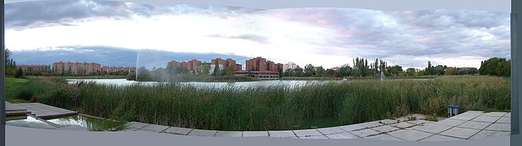 Lagoon of Laguna de Duero is a lake, which is situated 3 km northeast of Pinar de los Ingleses.
Church of Nuestra Señora de la Asunción, Laguna de Duero
Church

Photo: Rastrojo, CC BY-SA 3.0.
Church of Nuestra Señora de la Asunción, Laguna de Duero is situated 3 km northeast of Pinar de los Ingleses.
Places in the Area
Nearby places include Laguna de Duero and Puente Duero.
Laguna de Duero
Town
Laguna de Duero is a municipality located in the province of Valladolid, Castile and León, Spain. According to the 2016 census, the municipality has a population of 22,696 inhabitants. Laguna de Duero is situated 3 km northeast of Pinar de los Ingleses.
Puente Duero
Suburb

Photo: Iglesia en Valladolid, CC BY-SA 2.0.
Puente Duero is a suburb, which is situated 3½ km southwest of Pinar de los Ingleses.
Viana de Cega
Village

Photo: Rondador, CC BY-SA 4.0.
Viana de Cega is a municipality located in the province of Valladolid, Castile and León, Spain. According to the 2004 census, the municipality has a population of 1,716 inhabitants. Viana de Cega is situated 4½ km south of Pinar de los Ingleses.
Pinar de los Ingleses
- Type: Locality
- Location: Valladolid, Valladolid, Castile and León, Central Spain, Spain, Iberia, Europe
- View on OpenStreetMap
Latitude
41.5706° or 41° 34′ 14″ northLongitude
-4.75189° or 4° 45′ 7″ westOpen location code
8CHQH6CX+66OpenStreetMap ID
node 1242586353OpenStreetMap feature
place=locality
This page is based on OpenStreetMap, Wikidata, and Wikimedia Commons.
We’d love your help improving our open data sources. Thank you for contributing.
Satellite Map
Discover Pinar de los Ingleses from above in high-definition satellite imagery.
Localities in the Area
Explore places such as Pinar de Laguna and Las Encinas.
Notable Places Nearby
Highlights include Acuartelamiento Teniente Galiana and San Antonio de Padua.
Castile and León: Must-Visit Destinations
Delve into Salamanca, Segovia, León, and Burgos.
Curious Localities to Discover
Uncover intriguing localities from every corner of the globe.
About Mapcarta. Data © OpenStreetMap contributors and available under the Open Database License". Text is available under the CC BY-SA 4.0 license, except for photos, directions, and the map. Photo: Wikimedia, CC BY 2.5.