USA Apparel Group
USA Apparel Group is a factory in Honolulu County, Hawaii which is located on Leokane Street. USA Apparel Group is situated nearby to the recreation area iTrampoline Hawaii, as well as near the church Pacific Revival Center.| Tap on a place to explore it |
Places of Interest Nearby
Highlights include West Loch and Wakamiya Inari Shrine.
West Loch
Railway station

Photo: RickyCourtney, CC BY-SA 4.0.
Hōʻaeʻae station is a Skyline metro station in Waipahu, Hawaiʻi. It opened on June 30, 2023 along with its temporary 21-space park and ride lot. In Hawaiian, "hōʻaeʻae" means "to make soft or fine" and is the name of the ahupuaʻa in which it is located. West Loch is situated 1,800 feet northwest of USA Apparel Group.
Wakamiya Inari Shrine
Shinto shrine
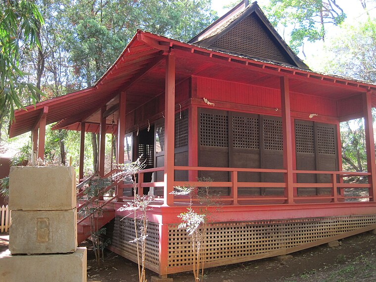
Photo: Joel Bradshaw, Public domain.
Wakamiya Inari Shrine at Waipahu Cultural Garden in Waipahu, Hawaiʻi, is the last surviving example of Inari Shrine architecture on Oʻahu. Unlike most Shinto shrines, which are unpainted, those dedicated to the fox deity Inari, the god of the harvest, are painted bright red. Wakamiya Inari Shrine is situated 1 mile northeast of USA Apparel Group.
Waipahu Transit Center
Railway station

Photo: RickyCourtney, CC BY-SA 4.0.
Pouhala station is a Skyline metro station in Waipahu, Hawaiʻi. It opened on June 30, 2023. In Hawaiian, "pouhala" means "pandanus post or pillar" and is the name of a former historically-important fishpond in the area and land division near Pearl Harbor, which today serves as a 70-acre wetland habitat for birds. Waipahu Transit Center is situated 1 mile northeast of USA Apparel Group.
Places in the Area
Nearby places include West Loch Estate and Village Park.
West Loch Estate
Neighborhood
West Loch Estate is a census-designated place in Honolulu County, Hawaiʻi, United States. The population was 5,523 at the 2020 census.
Village Park
Suburb
Village Park was a census-designated place in Honolulu County, Hawaiʻi, United States. The population was 9,625 at the 2000 census. For the 2010 census, it was replaced by the Royal Kunia CDP. Village Park is situated 1½ miles north of USA Apparel Group.
East Kapolei
Locality
East Kapolei is a census-designated place in Honolulu County, Hawaii, United States. It is on the south side of the island of Oahu and is bordered to the west by Kapolei, to the south by Ewa Villages, to the east by West Loch Estate, and to the north by Interstate H-1. East Kapolei is situated 2 miles southwest of USA Apparel Group.
USA Apparel Group
- Type: Factory
- Address: A, 94-125 Leokane Street, Waipahu, HI 96797
- Category: industry
- Location: Honolulu County, Hawaii, United States, North America
- View on OpenStreetMap
Latitude
21.37594° or 21° 22′ 33″ northLongitude
-158.01816° or 158° 1′ 5″ westOpen location code
73H39XGJ+9POpenStreetMap ID
node 12432867974OpenStreetMap feature
man_made=works
This page is based on OpenStreetMap, Wikidata, and Wikimedia Commons.
We’d love your help improving our open data sources. Thank you for contributing.
Satellite Map
Discover USA Apparel Group from above in high-definition satellite imagery.
Notable Places Nearby
Highlights include iTrampoline Hawaii and Pacific Revival Center.
Nearby Places
Explore places such as Harders Hawaii and SecureSpace Self Storage.
Hawaii: Must-Visit Destinations
Delve into Honolulu, Kauai, Hilo, and Molokai.
Curious Factories to Discover
Uncover intriguing factories from every corner of the globe.
About Mapcarta. Data © OpenStreetMap contributors and available under the Open Database License". Text is available under the CC BY-SA 4.0 license, except for photos, directions, and the map. Photo: Outdoorhighadventure, CC BY 3.0.