ESCUELA RUR ALTO DE MARTA
ESCUELA RUR ALTO DE MARTA is a school in Villanueva, Santander Department. ESCUELA RUR ALTO DE MARTA is situated nearby to the peak Alto Maria, as well as near the town Villanueva.| Tap on a place to explore it |
Places in the Area
Nearby places include Villanueva and Los Santos.
Villanueva
Town

Photo: Wikimedia, CC BY-SA 4.0.
Villanueva Villanueva es un municipio colombiano ubicado en el departamento de Santander, en la región nororiental del país. Hace parte de la provincia de Guanentá y se encuentra a una altitud aproximada de 1.600 metros sobre el nivel del mar, lo que le otorga un clima templado, ideal para la agricultura y el turismo rural. Villanueva is situated 3½ km southwest of ESCUELA RUR ALTO DE MARTA.
Los Santos
Town
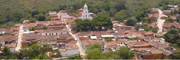
Photo: July salazar, CC BY-SA 4.0.
Los Santos is a town and municipality in the Santander Department in northeastern Colombia. Los Santos is situated 9 km northeast of ESCUELA RUR ALTO DE MARTA.
ESCUELA RUR ALTO DE MARTA
- Type: School
- Address: VILLANUEVA SANTANDER, SANTANDER
- Category: education
- Location: Villanueva, Santander Department, Colombia, South America
- View on OpenStreetMap
Latitude
6.68949° or 6° 41′ 22″ northLongitude
-73.14962° or 73° 8′ 59″ westOpen location code
67R8MVQ2+Q5OpenStreetMap ID
node 12480805518OpenStreetMap feature
amenity=school
This page is based on OpenStreetMap, Wikidata, and Wikimedia Commons.
We’d love your help improving our open data sources. Thank you for contributing.
Satellite Map
Discover ESCUELA RUR ALTO DE MARTA from above in high-definition satellite imagery.
Notable Places Nearby
Highlights include Alto Maria and BUENOS AIRES.
Nearby Places
Explore places such as escuela alto de martha and laguna de marta.
Colombia: Must-Visit Destinations
Delve into Bogotá, Medellín, Cali, and Cartagena.
Curious Schools to Discover
Uncover intriguing schools from every corner of the globe.
About Mapcarta. Data © OpenStreetMap contributors and available under the Open Database License". Text is available under the CC BY-SA 4.0 license, except for photos, directions, and the map. Photo: Wikimedia, CC0.