Co Creando
Co Creando is a clinic in Alvaro Obregon Borough, Mexico City which is located on Prolongación Paseo de la Reforma. Co Creando is situated nearby to the health club 9Round, as well as near the hospital Vista Diagnostica.| Tap on a place to explore it |
- Email: alegonzrza@hotmail.com
- Type: Clinic
- Address: Prolongación Paseo de la Reforma, 05348
Places of Interest Nearby
Highlights include Centro Santa Fe and La Mexicana Park.
Centro Santa Fe
Shopping center
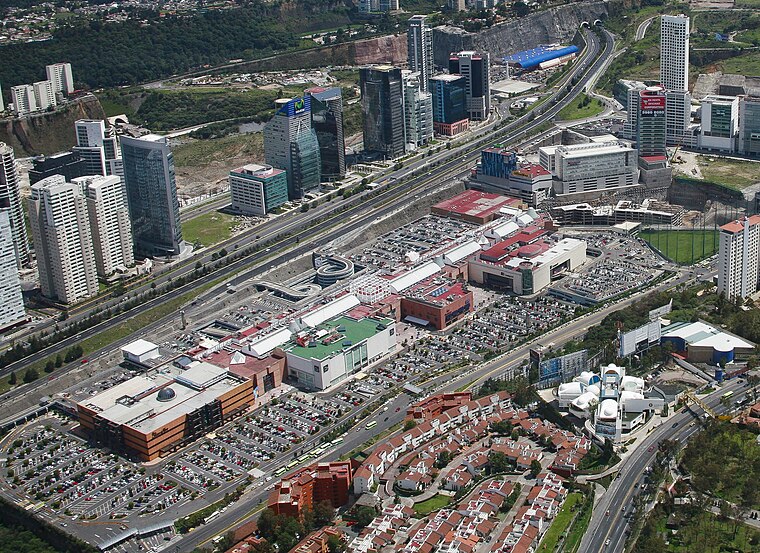 Centro Santa Fe is a large 210,400-square-metre enclosed shopping mall in the Santa Fe area in the far west side of Mexico City. Centro Santa Fe is the largest shopping center in Mexico. Centro Santa Fe is situated 290 metres northeast of Co Creando.
La Mexicana Park
Park

Photo: Alejandravgl, CC BY-SA 4.0.
La Mexicana Park is situated 440 metres southeast of Co Creando.
Torre Paradox

Photo: ClaraSanjurjo, CC BY-SA 4.0.
Torre Paradox is a residential skyscraper in the Chapultepec district of Mexico City, Mexico. Built between 2014 and 2018, the tower stands at 196.2 m tall with 60 floors, and is the current 15th tallest building in Mexico and the 8th tallest in Mexico City. Torre Paradox is situated 260 metres southeast of Co Creando.
Places in the Area
Nearby places include Santa Fe and Bosques de las Lomas.
Santa Fe

Photo: Serge Saint, CC BY 2.0.
Santa Fe is in the western area of Mexico City. It is the newest and most modern district of the city, as almost all of it has been developed only in the past twenty years; this puts this district in stark contrast with Mexico City's other districts, especially the Centro Historico.
Bosques de las Lomas
Neighborhood
Bosques de las Lomas is a colonia, or officially recognised neighbourhood, located in western Mexico City. It falls partly in Cuajimalpa borough and partly in Miguel Hidalgo borough. Bosques de las Lomas is situated 5 km northeast of Co Creando.
Santa Fe de Mexico
Village
Santa Fé de México was a Pueblo Hospital founded by Vasco de Quiroga in 1532. Its ruins are located in the town of Santa Fé in the delegación of Álvaro Obregón in western Mexico City. Santa Fe de Mexico is situated 5 km northeast of Co Creando.
Co Creando
- Category: health care
- Location: Alvaro Obregon Borough, Mexico City, Central Mexico, Mexico, North America
- View on OpenStreetMap
Latitude
19.35902° or 19° 21′ 33″ northLongitude
-99.27486° or 99° 16′ 30″ westOpen location code
76F29P5G+J3OpenStreetMap ID
node 12551346064OpenStreetMap feature
amenity=clinicOpenStreetMap feature
healthcare=clinic
This page is based on OpenStreetMap, Wikidata, and Wikimedia Commons.
We’d love your help improving our open data sources. Thank you for contributing.
Satellite Map
Discover Co Creando from above in high-definition satellite imagery.
Notable Places Nearby
Highlights include 9Round and Vista Diagnostica.
Nearby Places
Explore places such as Dntal Santa Fe and Mail Boxes Etc.
Mexico City: Must-Visit Destinations
Delve into Centro, Xochimilco, Coyoacán, and Condesa and Roma.
Curious Clinics to Discover
Uncover intriguing clinics from every corner of the globe.
About Mapcarta. Data © OpenStreetMap contributors and available under the Open Database License". Text is available under the CC BY-SA 4.0 license, except for photos, directions, and the map. Photo: Wikimedia, CC BY 2.0.