South Abingdon BMX Track
South Abingdon BMX Track is a recreation area in England, United Kingdom. South Abingdon BMX Track is situated nearby to the recreation area Abingdon Lawn Tennis Club, as well as near Abingdon Rugby Club.| Tap on a place to explore it |
Places of Interest Nearby
Highlights include Abingdon County Hall Museum and St Helen’s Church.
Abingdon County Hall Museum
Museum
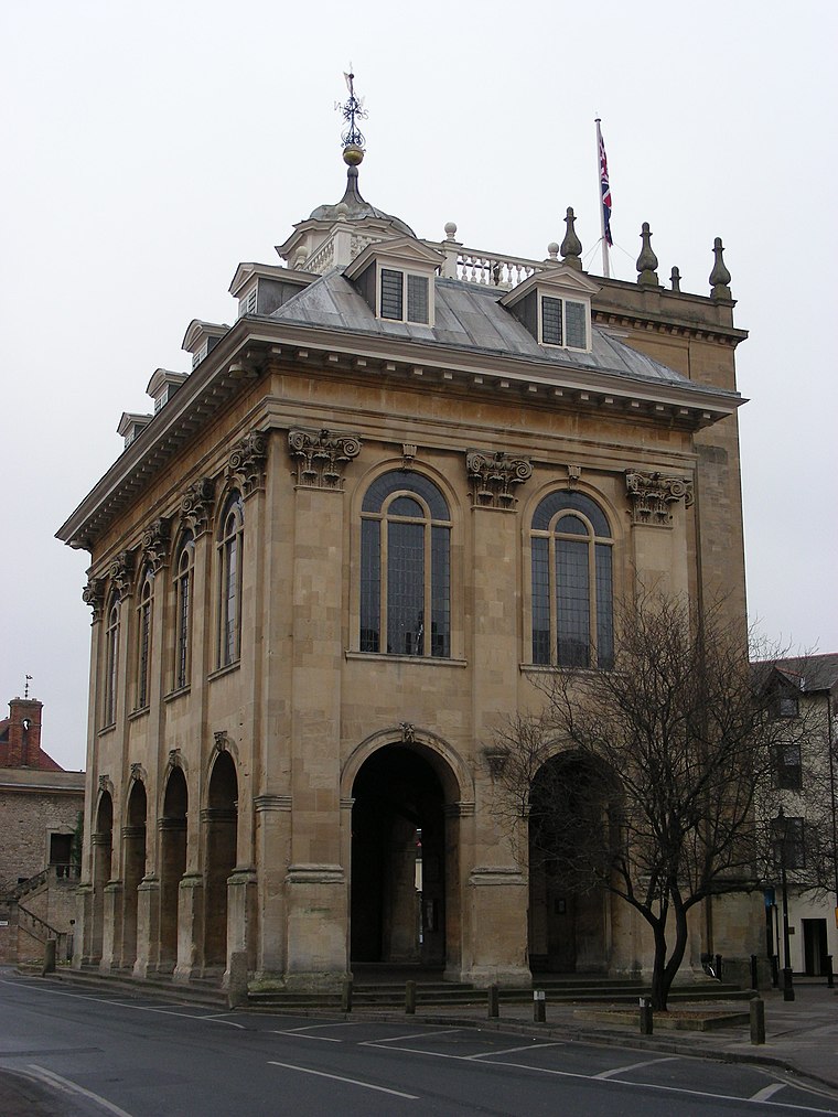
Photo: William M. Connolley, CC BY-SA 3.0.
Abingdon County Hall Museum is a local museum in Abingdon, Oxfordshire, England. The museum is run by Abingdon Town Council and supported by Abingdon Museum Friends, a registered charity. It is a Grade I listed building. Abingdon County Hall Museum is situated 1 mile northeast of South Abingdon BMX Track.
St Helen’s Church
Church

Photo: Colin Smith, CC BY-SA 2.0.
St Helen's Church is a Church of England parish church in Abingdon on the bank of the River Thames in Oxfordshire, England. The church is thought to occupy the site of the Anglo-Saxon Helenstowe Nunnery. St Helen’s Church is situated 1 mile northeast of South Abingdon BMX Track.
Abingdon Library
Library

Photo: Mike Faherty, CC BY-SA 2.0.
Abingdon Library is situated 1¼ miles north of South Abingdon BMX Track.
Places in the Area
Nearby places include Caldecott and Sutton Wick.
Caldecott
Suburb
Caldecott is a suburb of Abingdon in Oxfordshire, England. Caldecott was formerly part of Sutton Wick but is now part of Abingdon…
Sutton Wick
Locality

Photo: Steve Daniels, CC BY-SA 2.0.
Sutton Wick is a hamlet contiguous with the village of Drayton, in the Vale of White Horse district, in the county of Oxfordshire, England. It was part of Berkshire until the 1974 boundary changes transferred it to Oxfordshire.
Sutton Pools
Locality

Photo: Bill Nicholls, CC BY-SA 2.0.
Sutton Pools are a picturesque backwater formed by a number of weirs, islands, footbridges and barriers on the course of the River Thames at Sutton Courtenay, Oxfordshire, England.
South Abingdon BMX Track
- Type: Sports location
- Categories: recreation area and cycle sport
- Location: England, United Kingdom, Britain and Ireland, Europe
- View on OpenStreetMap
Latitude
51.65559° or 51° 39′ 20″ northLongitude
-1.29173° or 1° 17′ 30″ westOpen location code
9C3WMP45+68OpenStreetMap ID
node 12973720026OpenStreetMap feature
leisure=sportOpenStreetMap feature
sport=cycling
This page is based on OpenStreetMap, Wikidata, and Wikimedia Commons.
We’d love your help improving our open data sources. Thank you for contributing.
Satellite Map
Discover South Abingdon BMX Track from above in high-definition satellite imagery.
Notable Places Nearby
Highlights include South Abingdon BMX Track and Abingdon Lawn Tennis Club.
Nearby Places
Explore places such as Abingdon Sewage Treatment Works and Stonehill House.
England: Must-Visit Destinations
Delve into London, Manchester, Sheffield, and Leeds.
Curious Places to Discover
Uncover intriguing places from every corner of the globe.
About Mapcarta. Data © OpenStreetMap contributors and available under the Open Database License". Text is available under the CC BY-SA 4.0 license, except for photos, directions, and the map. Photo: sidibousaid, CC BY 2.0.