مسجد أبو روين الأثري
مسجد أبو روين الأثري is a mosque in Bahrain. مسجد أبو روين الأثري is situated nearby to the village Sehla, as well as near the mosque مسجد الشيخ عيسى.| Tap on a place to explore it |
- Type: Mosque
- Denomination: Shia
- Address: السهلة الجنوبية
Places of Interest Nearby
Highlights include Bahrain Fort and Khamis Mosque.
Bahrain Fort
Castle
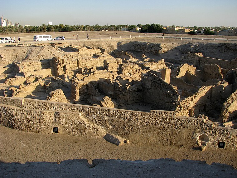 The Qal'at al-Bahrain, also known as the Bahrain Fort or Portuguese Fort, is an archaeological site located in Bahrain. Archaeological excavations carried out since 1954 have unearthed antiquities from an artificial mound of 12 m height containing seven stratified layers, created by various occupants from 2300 BC up to the 18th century, including Kassites, Greeks, Portuguese and Persians. Bahrain Fort is situated 3½ km north of مسجد أبو روين الأثري.
Khamis Mosque
Mosque

Photo: Rick’s Images, CC BY 2.0.
The Khamis Mosque is believed to be the first mosque in Bahrain, built during the era of the Umayyad caliph Umar II in Khamis. According to Al Wasat journalist Kassim Hussain, other sources mention that it was built in a later era during the rule of Uyunids with one minaret. Khamis Mosque is situated 1½ km northeast of مسجد أبو روين الأثري.
Adhari Park
Theme park
Adhari Park is an amusement park in the Kingdom of Bahrain based around the historic freshwater spring known as Ain Adhari which is located around the Zinj area. Adhari Park is situated 1¼ km east of مسجد أبو روين الأثري.
Places in the Area
Nearby places include Sehla and Abu Baham.
Sehla
Village
North Sehla is a village located in the north of Bahrain, on the outskirts of the capital city Manama. It is located in the Northern Governorate administrative region and is west of Khamis.
Abu Baham
Village
Abu Baham is a small village situated in the northern region of the Kingdom of Bahrain, on the western outskirts of the capital city Manama. The village lies under the Northern Governorate administrative region.
Salmabad
Village
Salmabad is a town in the center of Bahrain Island. Many businesses and factories are located in the Salmabad area. It has been developed as an industrial area in Bahrain.
مسجد أبو روين الأثري
- Categories: building, place of worship, and religion
- Location: Bahrain, Middle East, Asia
- View on OpenStreetMap
Latitude
26.2027° or 26° 12′ 10″ northLongitude
50.53405° or 50° 32′ 3″ eastOpen location code
7HRG6G3M+3JOpenStreetMap ID
node 13002316025OpenStreetMap feature
amenity=place_of_worshipOpenStreetMap feature
building=mosqueOpenStreetMap attribute
denomination=shia
This page is based on OpenStreetMap, Wikidata, and Wikimedia Commons.
We’d love your help improving our open data sources. Thank you for contributing.
Satellite Map
Discover مسجد أبو روين الأثري from above in high-definition satellite imagery.
Notable Places Nearby
Highlights include مسجد الشيخ عيسى and مسجد الشيخ حسين.
Nearby Places
Explore places such as Fabtech and Salami Furniture.
Bahrain: Must-Visit Destinations
Delve into Manama, Muharraq, Riffa, and Southern Governorate.
Curious Mosques to Discover
Uncover intriguing mosques from every corner of the globe.
About Mapcarta. Data © OpenStreetMap contributors and available under the Open Database License". Text is available under the CC BY-SA 4.0 license, except for photos, directions, and the map. Photo: Peter, CC BY 2.0.