Via Borromeo
Via Borromeo is a tram stop in Rubano, Padova, Veneto. Via Borromeo is situated nearby to the community center Banca Del Tempo Rubano, as well as near the square Piazza Adelaide Lonigo.| Tap on a place to explore it |
Places of Interest Nearby
Highlights include Le Calandre and Stadio Euganeo.
Le Calandre
Restaurant

Photo: City Foodsters, CC BY 2.0.
Le Calandre is a restaurant in the village of Sarmeola di Rubano 6 kilometres west of Padua, Italy. Le Calandre is situated 280 metres west of Via Borromeo.
Stadio Euganeo
Stadium
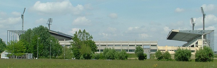
Photo: LigaDue, CC BY-SA 3.0.
Stadio Euganeo is a multipurpose stadium located in Padua, Italy. Primarily used for football, it is also used for athletics events, concerts, rugby league and rugby union matches. Stadio Euganeo is situated 4 km east of Via Borromeo.
Padua “Gino Allegri” Airport
Aerodrome

Photo: Aplasia, CC BY-SA 3.0.
Padua "Gino Allegri" Airport is an airport serving Padua, Veneto, Italy. The airport is named after Gino Allegri, an Italian aviator who lost his life while attempting to land in a small airfield in the Province of Padua during World War I. Padua “Gino Allegri” Airport is situated 4 km southeast of Via Borromeo.
Places in the Area
Nearby places include Rubano and Bosco.
Rubano
Town

Photo: Xaneitaly, CC BY-SA 4.0.
Rubano is a comune in the Province of Padua in the Italian region Veneto, located about 40 kilometres west of Venice and about 7 kilometres northwest of Padua.
Bosco
Village

Photo: Filippof, CC BY-SA 3.0.
Bosco is a village, which is situated 3 km northwest of Via Borromeo.
Selvazzano Dentro
Town
Photo: Vipera, Public domain.
Selvazzano Dentro is a comune in the province of Padua, Veneto, northeast Italy, located about 40 kilometres west of Venice and about 8 kilometres southwest of Padua. Selvazzano Dentro is situated 4 km southwest of Via Borromeo.
Via Borromeo
- Type: Tram stop
- Category: transportation
- Location: Rubano, Padova, Veneto, Northeast Italy, Italy, Europe
- View on OpenStreetMap
Latitude
45.42084° or 45° 25′ 15″ northLongitude
11.81295° or 11° 48′ 47″ eastOpen location code
8FQHCRC7+85OpenStreetMap ID
node 13017491330OpenStreetMap feature
public_transport=platformOpenStreetMap feature
railway=tram_stop
This page is based on OpenStreetMap, Wikidata, and Wikimedia Commons.
We’d love your help improving our open data sources. Thank you for contributing.
Satellite Map
Discover Via Borromeo from above in high-definition satellite imagery.
Notable Places Nearby
Highlights include Banca Del Tempo Rubano and Piazza Adelaide Lonigo.
Nearby Places
Explore places such as Via Borromeo and Centro per le famiglie.
Curious Tram Stops to Discover
Uncover intriguing tram stops from every corner of the globe.
About Mapcarta. Data © OpenStreetMap contributors and available under the Open Database License". Text is available under the CC BY-SA 4.0 license, except for photos, directions, and the map. Photo: Pmk58, CC BY-SA 4.0.