Brentella Est
Brentella Est is a tram stop in Rubano, Padova, Veneto. Brentella Est is situated nearby to Villa Zanicatti, as well as near the sports venue Spartan Club.| Tap on a place to explore it |
Places of Interest Nearby
Highlights include Scrovegni Chapel and Stadio Euganeo.
Scrovegni Chapel
Museum

Photo: Piroddi.andrea, CC BY-SA 3.0.
The Scrovegni Chapel, also known as the Arena Chapel, is a small church, adjacent to the Augustinian monastery, the Monastero degli Eremitani in Padua, region of Veneto, Italy. Scrovegni Chapel is situated 4 km east of Brentella Est.
Stadio Euganeo
Stadium
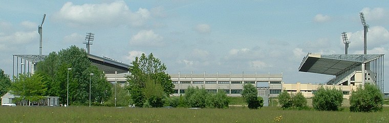
Photo: LigaDue, CC BY-SA 3.0.
Stadio Euganeo is a multipurpose stadium located in Padua, Italy. Primarily used for football, it is also used for athletics events, concerts, rugby league and rugby union matches. Stadio Euganeo is situated 3 km northeast of Brentella Est.
Palazzo della Ragione
Museum

Photo: Archaeodontosaurus, CC BY-SA 4.0.
The Palazzo della Ragione is a medieval market hall, town hall and palace of justice building in Padua, in the Veneto region of Italy. The upper floor was dedicated to the town and justice administration; while the ground floor still hosts the historical covered market of the city. Palazzo della Ragione is situated 3½ km east of Brentella Est.
Places in the Area
Nearby places include Rubano and Padua.
Rubano
Town

Photo: Xaneitaly, CC BY-SA 4.0.
Rubano is a comune in the Province of Padua in the Italian region Veneto, located about 40 kilometres west of Venice and about 7 kilometres northwest of Padua. Rubano is situated 3½ km northwest of Brentella Est.
Padua
 Padua is a city in north eastern Italy, and the capital of the province of the same name. It is located centrally in the Veneto region, between Venice on one side and Vicenza and Verona on the other.
Bosco
Village

Photo: Filippof, CC BY-SA 3.0.
Bosco is a village, which is situated 4 km northwest of Brentella Est.
Brentella Est
- Type: Tram stop
- Category: transportation
- Location: Rubano, Padova, Veneto, Northeast Italy, Italy, Europe
- View on OpenStreetMap
Latitude
45.41646° or 45° 24′ 59″ northLongitude
11.82977° or 11° 49′ 47″ eastOpen location code
8FQHCR8H+HWOpenStreetMap ID
node 13017491335OpenStreetMap feature
public_transport=platformOpenStreetMap feature
railway=tram_stop
This page is based on OpenStreetMap, Wikidata, and Wikimedia Commons.
We’d love your help improving our open data sources. Thank you for contributing.
Satellite Map
Discover Brentella Est from above in high-definition satellite imagery.
Notable Places Nearby
Highlights include Spartan Club and Villa Zanicatti.
Nearby Places
Explore places such as San Sushi Padova and Brentella Est.
Curious Tram Stops to Discover
Uncover intriguing tram stops from every corner of the globe.
About Mapcarta. Data © OpenStreetMap contributors and available under the Open Database License". Text is available under the CC BY-SA 4.0 license, except for photos, directions, and the map. Photo: Pmk58, CC BY-SA 4.0.