Meadow Picnic Area
Meadow Picnic Area is a picnic site in San Mateo, California. Meadow Picnic Area is situated nearby to the town hall Belmont City Hall, as well as near Good Shepherd Episcopal Church.| Tap on a place to explore it |
Places of Interest Nearby
Highlights include Belmont station and Notre Dame High School.
Belmont station
Railway station

Photo: Pi.1415926535, CC BY-SA 4.0.
Belmont station is a Caltrain station in Belmont, California that replaced the Southern Pacific Railroad station nearby. It is served by local and limited service trains. Belmont station is situated 1,400 feet north of Meadow Picnic Area.
Notre Dame High School
School
Notre Dame High School, Belmont is a Catholic women's college preparatory high school located in the San Mateo County suburb of Belmont, California. The school is operated by the Sisters of Notre Dame de Namur for the Archdiocese of San Francisco. Notre Dame High School is situated 2,900 feet west of Meadow Picnic Area.
Ralston Hall
Building
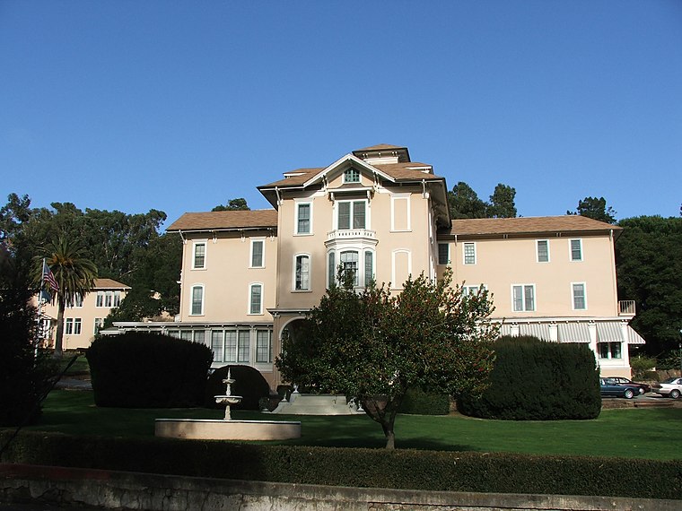
Photo: Kglavin, CC BY-SA 3.0.
Ralston Hall Mansion located in Belmont, California, was the country house of William Chapman Ralston, a San Francisco businessman, a founder of the Bank of California, and a financier of the Comstock Lode. Ralston Hall is situated 2,900 feet west of Meadow Picnic Area.
Places in the Area
Nearby places include Belmont and San Carlos.
Belmont
Photo: Kglavin, CC BY-SA 3.0.
Belmont is a city in San Mateo County, California, United States. It is in the San Francisco Bay Area, on the San Francisco Peninsula about halfway between San Francisco and San Jose.
San Carlos

Photo: CityofSanCarlos, CC BY-SA 4.0.
San Carlos is on the Peninsula in the San Francisco Bay Area of California.
Redwood Shores
Hamlet

Photo: BrokenSphere, CC BY-SA 3.0.
Redwood Shores is a waterfront community in Redwood City, California, along the western shore of San Francisco Bay on the San Francisco Peninsula in San Mateo County. Redwood Shores is situated 2 miles northeast of Meadow Picnic Area.
Meadow Picnic Area
- Type: Picnic site
- Category: tourism
- Location: San Mateo, California, United States, North America
- View on OpenStreetMap
Latitude
37.51745° or 37° 31′ 3″ northLongitude
-122.27676° or 122° 16′ 36″ westOpen location code
849VGP8F+X7OpenStreetMap ID
node 1312471185OpenStreetMap feature
tourism=picnic_site
This page is based on OpenStreetMap, Wikidata, and Wikimedia Commons.
We’d love your help improving our open data sources. Thank you for contributing.
Satellite Map
Discover Meadow Picnic Area from above in high-definition satellite imagery.
Places with the Same Name
Discover other places named “Meadow Picnic Area”.
Notable Places Nearby
Highlights include Belmont City Hall and Good Shepherd Episcopal Church.
Nearby Places
Explore places such as Acupuncture and Charles McDonald.
California: Must-Visit Destinations
Delve into San Francisco, Los Angeles, San Diego, and Sacramento.
Curious Picnic Sites to Discover
Uncover intriguing picnic sites from every corner of the globe.
About Mapcarta. Data © OpenStreetMap contributors and available under the Open Database License". Text is available under the CC BY-SA 4.0 license, except for photos, directions, and the map. Photo: Wikimedia, CC BY-SA 2.0.