M.T.Bellies
M.T.Bellies is a fast food restaurant in Peterborough, England. M.T.Bellies is situated nearby to St John Fisher Catholic High School, as well as near Loveworld Church a.k.a. Christ Embassy Peterborough.| Tap on a place to explore it |
Places of Interest Nearby
Highlights include St John Fisher Catholic High School and Showcase Cinema de Lux Peterborough.
St John Fisher Catholic High School
School
St John Fisher Catholic High School, formerly known as St. John Fisher RC Comprehensive School, is in the city of Peterborough, England, and is the only Catholic school in Cambridgeshire. St John Fisher Catholic High School is situated 1,200 feet northwest of M.T.Bellies.
Showcase Cinema de Lux Peterborough
Movie theater

Photo: Mickey McCarthy, Public domain.
Showcase Cinema de Lux Peterborough is a movie theater, which is situated 2,000 feet southwest of M.T.Bellies.
Peterborough Cathedral
Church
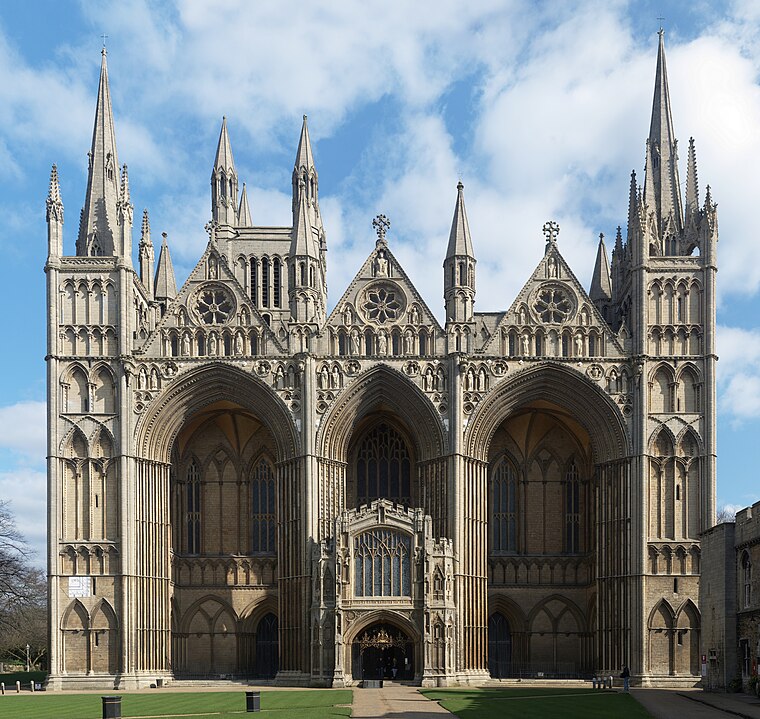
Photo: NotFromUtrecht, CC BY-SA 3.0.
Peterborough Cathedral, properly the Cathedral Church of St Peter, St Paul and St Andrew, and formerly known as Peterborough Abbey or St Peter's Abbey, is a cathedral in Peterborough, Cambridgeshire, in the United Kingdom. Peterborough Cathedral is situated 1 mile southwest of M.T.Bellies.
Places in the Area
Nearby places include Eastgate and Peterborough.
Eastgate
Suburb
Eastgate is a suburb of Peterborough, in the ceremonial county of Cambridgeshire, England. It lies immediately to the east of Peterborough Cathedral and west of Fengate.
Peterborough

Photo: Mdbeckwith, CC0.
Peterborough is a city in Cambridgeshire in East Anglia, with a population of 202,259 in 2019. It's industrial and ringed by bland "New Town" residential districts, yet has an attractive historic centre around its cathedral, where two British monarchs were buried.
Dogsthorpe
Suburb

Photo: Jay Haywood, CC BY-SA 2.0.
Dogsthorpe is a residential area and electoral ward of the city of Peterborough, in the Peterborough district, in the ceremonial county of Cambridgeshire, England.
M.T.Bellies
- Type: Fast food restaurant
- Categories: food and restaurant
- Location: Peterborough, England, United Kingdom, Britain and Ireland, Europe
- View on OpenStreetMap
Latitude
52.57896° or 52° 34′ 44″ northLongitude
-0.21891° or 0° 13′ 8″ westOpen location code
9C4XHQHJ+HCOpenStreetMap ID
node 13136439772OpenStreetMap feature
amenity=fast_food
This page is based on OpenStreetMap, Wikidata, and Wikimedia Commons.
We’d love your help improving our open data sources. Thank you for contributing.
Satellite Map
Discover M.T.Bellies from above in high-definition satellite imagery.
Places with the Same Name
Discover other places named “M.T.Bellies”.
Notable Places Nearby
Highlights include Loveworld Church a.k.a. Christ Embassy Peterborough and City of Peterborough Academy.
Nearby Places
Explore places such as Sterling Bolt & Nut Co. Ltd and Escape Campers.
England: Must-Visit Destinations
Delve into London, Manchester, Sheffield, and Leeds.
Curious Fast Food Restaurants to Discover
Uncover intriguing fast food restaurants from every corner of the globe.
About Mapcarta. Data © OpenStreetMap contributors and available under the Open Database License". Text is available under the CC BY-SA 4.0 license, except for photos, directions, and the map. Photo: sidibousaid, CC BY 2.0.