Sewage Beds Cheddar Substation
Sewage Beds Cheddar Substation is an electrical substation in Cheddar, Sedgemoor District, England. Sewage Beds Cheddar Substation is situated nearby to the building Cheddar railway station, as well as near the park All Weather Pitch.| Tap on a place to explore it |
Places of Interest Nearby
Highlights include The Kings of Wessex Academy and Cheddar Reservoir.
The Kings of Wessex Academy
School
The Kings of Wessex Academy, formerly known as the Kings of Wessex School, is a co-educational comprehensive secondary school in Cheddar, Somerset, England. The Kings of Wessex Academy is situated 2,800 feet northeast of Sewage Beds Cheddar Substation.
Cheddar Reservoir
Reservoir
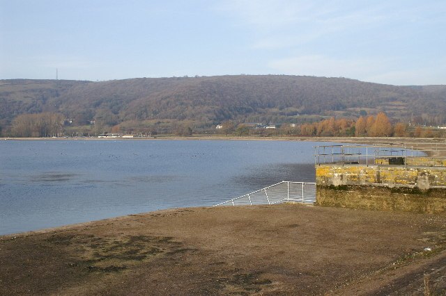
Photo: Adrian and Janet Quantock, CC BY-SA 2.0.
Cheddar Reservoir is an artificial reservoir in Somerset, England, operated by Bristol Water. Dating from the 1930s it has a capacity of 135 million gallons.
St Andrew’s Church, Cheddar
Church
 The Church of St Andrew in Cheddar, Somerset, England dates from the 14th century and has been designated as a Grade I listed building. The church was restored in 1873 by William Butterfield. St Andrew’s Church, Cheddar is situated 3,600 feet northeast of Sewage Beds Cheddar Substation.
Places in the Area
Nearby places include Axbridge and Draycott.
Axbridge
Town

Photo: Martin Clark, CC BY-SA 2.0.
Axbridge is a town in Somerset, England, on the River Axe, near the southern edge of the Mendip Hills. Its population according to the 2011 census was 2,057. Axbridge is situated 1½ miles northwest of Sewage Beds Cheddar Substation.
Draycott
Village

Photo: Adrian and Janet Quantock, CC BY-SA 2.0.
Draycott is a village in Somerset, England, neighbouring the village of Cheddar on the southern edge of the Mendip Hills Area of Outstanding Natural Beauty. It is now the larger village in the civil parish of Rodney Stoke. Draycott is situated 2 miles southeast of Sewage Beds Cheddar Substation.
Rodney Stoke
Village

Photo: Adrian and Janet Quantock, CC BY-SA 2.0.
Rodney Stoke is a small village and civil parish, located at grid reference ST486501, 5 miles north-west of Wells, in the English county of Somerset. The village is on the A371 between Draycott and Westbury-sub-Mendip. Rodney Stoke is situated 3 miles southeast of Sewage Beds Cheddar Substation.
Sewage Beds Cheddar Substation
- Type: Electrical substation
- Category: industry
- Location: Cheddar, Sedgemoor District, Somerset, West Country, England, United Kingdom, Britain and Ireland, Europe
- View on OpenStreetMap
Latitude
51.26995° or 51° 16′ 12″ northLongitude
-2.79048° or 2° 47′ 26″ westOpen location code
9C3V7695+XROpenStreetMap ID
node 13138202314
This page is based on OpenStreetMap, Wikidata, and Wikimedia Commons.
We’d love your help improving our open data sources. Thank you for contributing.
Satellite Map
Discover Sewage Beds Cheddar Substation from above in high-definition satellite imagery.
Notable Places Nearby
Highlights include Cheddar railway station and All Weather Pitch.
Nearby Places
Explore places such as FSC and Steart Farm.
Somerset: Must-Visit Destinations
Delve into Bristol, Bath, Wells, and Taunton.
Curious Electrical Substations to Discover
Uncover intriguing electrical substations from every corner of the globe.
About Mapcarta. Data © OpenStreetMap contributors and available under the Open Database License". Text is available under the CC BY-SA 4.0 license, except for photos, directions, and the map. Photo: Delta 51, CC BY-SA 4.0.