Glendon Wood Hospital
Glendon Wood Hospital is a hospital in Weekley, Kettering District, England. Glendon Wood Hospital is situated nearby to the police station Police Investigation Centre, as well as near the forest Weekley Hall Wood.| Tap on a place to explore it |
Places of Interest Nearby
Highlights include Rushton Triangular Lodge and Kettering General Hospital.
Rushton Triangular Lodge
Castle

Photo: Wikimedia, CC BY-SA 2.0.
The Triangular Lodge is a folly, designed by Sir Thomas Tresham and constructed between 1593 and 1597 near Rushton, Northamptonshire, England. It is now in the care of English Heritage. Rushton Triangular Lodge is situated 2½ miles northwest of Glendon Wood Hospital.
Kettering General Hospital
Hospital
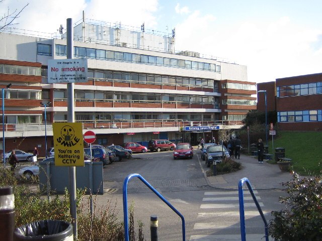
Photo: John Winterbottom, CC BY-SA 2.0.
Kettering General Hospital is an NHS district hospital in Kettering, Northamptonshire, England. Mainly serving the unitary authority area of North Northamptonshire, it is managed by the Kettering General Hospital NHS Foundation Trust. Kettering General Hospital is situated 1½ miles south of Glendon Wood Hospital.
Montagu Hospital
Historic building

Photo: Richard Croft, CC BY-SA 2.0.
Montagu Hospital is a historic building, which is situated 1½ miles east of Glendon Wood Hospital.
Places in the Area
Nearby places include Newton and Kettering.
Newton
Village
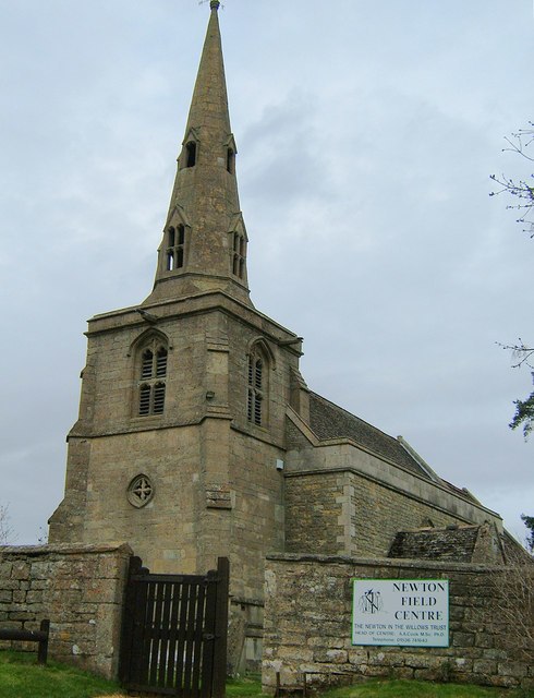
Photo: John Stolarski, CC BY-SA 2.0.
Newton, sometimes called Newton in the Willows, is a small village and former civil parish, now in the parish of Newton and Little Oakley, in the North Northamptonshire district, in the ceremonial county of Northamptonshire, England. Newton is situated 1½ miles northeast of Glendon Wood Hospital.
Kettering

Photo: Wikimedia, CC BY-SA 2.0.
Kettering is a town of 60,749 people in north Northamptonshire. Kettering owes much of its heritage and growth to the arrival of the railway during the mid-1800s.
Geddington
Village
 Geddington is a village and civil parish on the A4300, previously A43, in North Northamptonshire between Kettering and Corby. The population of the civil parish at the 2011 census was 1,503, virtually unchanged from 1,504 at the 2001 census. Geddington is situated 2 miles northeast of Glendon Wood Hospital.
Glendon Wood Hospital
- Type: Hospital
- Postal code: NN14 1QF
- Category: health care
- Location: Weekley, Kettering District, North Northamptonshire, England, United Kingdom, Britain and Ireland, Europe
- View on OpenStreetMap
Latitude
52.42434° or 52° 25′ 28″ northLongitude
-0.73203° or 0° 43′ 55″ westOpen location code
9C4XC7F9+P5OpenStreetMap ID
node 13175700601OpenStreetMap feature
amenity=hospital
This page is based on OpenStreetMap, Wikidata, and Wikimedia Commons.
We’d love your help improving our open data sources. Thank you for contributing.
Satellite Map
Discover Glendon Wood Hospital from above in high-definition satellite imagery.
Notable Places Nearby
Highlights include Police Investigation Centre and Weekley Hall Wood.
Nearby Places
Explore places such as Argos Distribution Centre (opp) and Argos Distribution Centre (o/s).
England: Must-Visit Destinations
Delve into London, Manchester, Sheffield, and Leeds.
Curious Places to Discover
Uncover intriguing places from every corner of the globe.
About Mapcarta. Data © OpenStreetMap contributors and available under the Open Database License". Text is available under the CC BY-SA 4.0 license, except for photos, directions, and the map. Photo: sidibousaid, CC BY 2.0.