The New Pad
The New Pad is a fast food restaurant in Belfast, County Antrim, Northern Ireland. The New Pad is situated nearby to The Flax Centre Post Office, as well as near the community center ardoyne community centre.| Tap on a place to explore it |
Places of Interest Nearby
Highlights include Solitude and HM Prison Belfast.
Solitude
Pitch
 Solitude is a football stadium in north Belfast, Northern Ireland. Home ground of Ireland's oldest football club, Cliftonville, it is the oldest football stadium in Ireland. Solitude is situated 2,600 feet northeast of The New Pad.
HM Prison Belfast
Museum
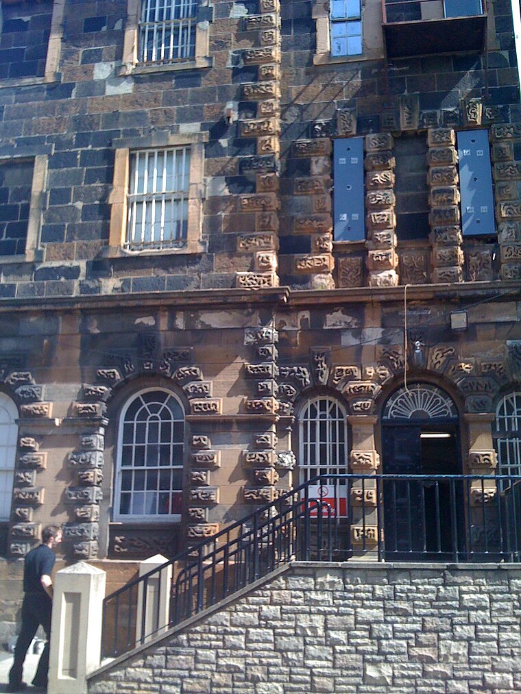
Photo: Agadant, CC BY-SA 3.0.
HM Prison Belfast, also known as Crumlin Road Gaol, is a former prison situated on the Crumlin Road in north Belfast, Northern Ireland. Since 1996 it is the only remaining Victorian era former prison in Northern Ireland. HM Prison Belfast is situated 3,700 feet southeast of The New Pad.
Crumlin Road Courthouse
Courthouse

Photo: Merville Garden Village, CC BY-SA 4.0.
The Crumlin Road Courthouse is a former judicial facility on Crumlin Road in Belfast, Northern Ireland. It is a Grade B+ listed building. Crumlin Road Courthouse is situated 3,900 feet southeast of The New Pad.
Places in the Area
Nearby places include New Lodge and Cathedral Quarter.
New Lodge
Suburb

Photo: Gerry Lynch, CC BY 2.5.
The New Lodge is an urban, working class Catholic community in Belfast, Northern Ireland, immediately to the north of the city centre. The landscape is dominated by several large tower blocks.
Cathedral Quarter
Quarter

Photo: Stuart, CC BY-SA 2.0.
The Cathedral Quarter in Belfast, Northern Ireland, is a developing area of the city, roughly situated between Royal Avenue near where the Belfast Central Library building is, and the Dunbar Link in the city centre.
Linen Quarter
Quarter

Photo: Wikimedia, Public domain.
The Linen Quarter is an area of Belfast, Northern Ireland. The name is derived from the great many linen warehouses that are still present in the area. Linen Quarter is situated 2 miles southeast of The New Pad.
The New Pad
- Type: Fast food restaurant
- Cuisine: fish and chips
- Categories: food and restaurant
- Location: Belfast, County Antrim, Northern Ireland, United Kingdom, Britain and Ireland, Europe
- View on OpenStreetMap
Latitude
54.61506° or 54° 36′ 54″ northLongitude
-5.95677° or 5° 57′ 24″ westOpen location code
9C6PJ28V+27OpenStreetMap ID
node 13198913439OpenStreetMap feature
amenity=fast_foodOpenStreetMap attribute
cuisine=fish_and_chips
This page is based on OpenStreetMap, Wikidata, and Wikimedia Commons.
We’d love your help improving our open data sources. Thank you for contributing.
Satellite Map
Discover The New Pad from above in high-definition satellite imagery.
Notable Places Nearby
Highlights include The Flax Centre Post Office and The Flax Centre.
Nearby Places
Explore places such as Day-Today and Holy Cross Nursery School.
County Antrim: Must-Visit Destinations
Delve into Giant’s Causeway, Lisburn, Ballymena, and Larne.
Curious Fast Food Restaurants to Discover
Uncover intriguing fast food restaurants from every corner of the globe.
About Mapcarta. Data © OpenStreetMap contributors and available under the Open Database License". Text is available under the CC BY-SA 4.0 license, except for photos, directions, and the map. Photo: AlasdairW, CC BY-SA 3.0.