Arnos Food & Wine
Arnos Food & Wine is a supermarket in Enfield, Greater London, England which is located on Bowes Road. Arnos Food & Wine is situated nearby to Palmers Green and Southgate District Synagogue, as well as near the church North London Assembly Hall of Jehovah’s Witnesses.| Tap on a place to explore it |
- Opening hours: 6:00 AM—10:30 PM
- Type: Supermarket
- Address: 165 Bowes Road, London, N11 2JA
Places of Interest Nearby
Highlights include Bowes Park railway station and Laurel Park School.
Bowes Park railway station
Railway station

Photo: Sunil060902, CC BY-SA 3.0.
Bowes Park railway station is in the London Borough of Haringey in north London, and is on the boundary of London fare zone 3 and 4. It is 5 miles 55 chains down the line from London King's Cross. Bowes Park railway station is situated 2,100 feet south of Arnos Food & Wine.
Laurel Park School
School

Photo: Philafrenzy, CC BY-SA 4.0.
Laurel Park School, formerly Broomfield School, is a comprehensive secondary school located in Arnos Grove, Enfield, Greater London, which resulted from a merger of Arnos School and Minchenden School. Laurel Park School is situated 750 feet northwest of Arnos Food & Wine.
Bounds Green tube station
Metro station
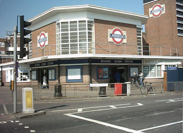
Photo: Voyager, Public domain.
Bounds Green is a London Underground station. It is located at the junction of Bounds Green Road and Brownlow Road in Bounds Green in the London Borough of Haringey, North London. Bounds Green tube station is situated 2,100 feet south of Arnos Food & Wine.
Places in the Area
Nearby places include Bowes Park and Palmers Green.
Bowes Park
Quarter
Photo: Mcsony, CC BY-SA 3.0.
Bowes Park is situated on the borders of Wood Green, Palmers Green and Bounds Green in London, England. The postcodes for Bowes Park are N11, N13 and N22.
Palmers Green
Suburb

Photo: John Salmon, CC BY-SA 2.0.
Palmers Green is a suburban area in north London, England, within the London Borough of Enfield. It is located within the N13 postcode district, around 8 miles north of Charing Cross.
New Southgate
Suburb

Photo: IceDragon64, Public domain.
New Southgate is a residential suburb straddling three Outer London Boroughs: a small part of the east of Barnet, a south-west corner of Enfield and in loosest definitions, based on nearest railway stations, a small northern corner of Haringey in North London, England where estates merge into Bounds Green.
Arnos Food & Wine
- Categories: shop and food
- Location: Enfield, Greater London, England, United Kingdom, Britain and Ireland, Europe
- View on OpenStreetMap
Latitude
51.61289° or 51° 36′ 46″ northLongitude
-0.12207° or 0° 7′ 19″ westOperator
Lifestyle ExpressOpen location code
9C3XJV7H+55OpenStreetMap ID
node 13204765224OpenStreetMap feature
shop=supermarket
This page is based on OpenStreetMap, Wikidata, and Wikimedia Commons.
We’d love your help improving our open data sources. Thank you for contributing.
Satellite Map
Discover Arnos Food & Wine from above in high-definition satellite imagery.
Notable Places Nearby
Highlights include Palmers Green and Southgate District Synagogue and North London Assembly Hall of Jehovah’s Witnesses.
Nearby Places
Explore places such as N13 Dental Clinic and Bowes Road.
England: Must-Visit Destinations
Delve into London, Manchester, Sheffield, and Leeds.
Curious Supermarkets to Discover
Uncover intriguing supermarkets from every corner of the globe.
About Mapcarta. Data © OpenStreetMap contributors and available under the Open Database License". Text is available under the CC BY-SA 4.0 license, except for photos, directions, and the map. Photo: sidibousaid, CC BY 2.0.