Lady Knoll
Lady Knoll is a locality in Ebberston and Yedingham, Ryedale District, England. Lady Knoll is situated nearby to the locality Coulton Cliff, as well as near Hazel Balk.| Tap on a place to explore it |
Places of Interest
Highlights include Church of St Stephen and St Mary’s Church, Ebberston.

St Mary’s Church, Ebberston
Church

Photo: Phil Catterall, CC BY-SA 2.0.
St Mary's Church is the parish church of Ebberston, a village in North Yorkshire, in England. The church was built in the 12th century, at which time it appears to have consisted of a nave and chancel.
Grapes Inn
Pub

Photo: Martin Dawes, CC BY-SA 2.0.
The Grapes Inn is a historic pub in Ebberston, a village in North Yorkshire, in England. The building largely dates from the late 18th century, although it has earlier origins.
Places in the Area
Nearby places include Ebberston and Yedingham.
Ebberston
Village

Photo: Trish Steel, CC BY-SA 2.0.
Ebberston is a village and former civil parish, now in the parish of Ebberston and Yedingham in North Yorkshire, England, and is 34 miles east from the county town of Northallerton. In 1961 the parish had a population of 466.
Yedingham
Village
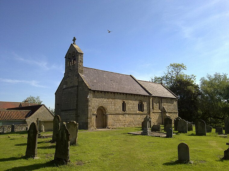
Photo: Nigelcoates, CC BY-SA 3.0.
Yedingham is a village and former civil parish, now in the parish of Ebberston and Yedingham, halfway between West Knapton and Allerston, nine miles north-east of Malton in North Yorkshire, England. Yedingham is situated 2 miles south of Lady Knoll.
Brompton by Sawdon
Village

Photo: Nigelcoates, CC BY-SA 3.0.
Brompton-by-Sawdon is a village in the Brompton civil parish of North Yorkshire district and county, England. The civil parish includes the village and the village of Sawdon. Brompton by Sawdon is situated 2½ miles east of Lady Knoll.
Lady Knoll
Latitude
54.23153° or 54° 13′ 54″ northLongitude
-0.6116° or 0° 36′ 42″ westOpen location code
9C6X69JQ+J9OpenStreetMap ID
node 13205768600OpenStreetMap feature
place=locality
This page is based on OpenStreetMap, Wikidata, and Wikimedia Commons.
We’d love your help improving our open data sources. Thank you for contributing.
Satellite Map
Discover Lady Knoll from above in high-definition satellite imagery.
Localities in the Area
Explore places such as Coulton Cliff and Hazel Balk.
Notable Places Nearby
Highlights include Snainton Golf and Ebberston Village Hall.
North Yorkshire: Must-Visit Destinations
Delve into York, Middlesbrough, Scarborough, and Ripon.
Curious Localities to Discover
Uncover intriguing localities from every corner of the globe.
About Mapcarta. Data © OpenStreetMap contributors and available under the Open Database License". Text is available under the CC BY-SA 4.0 license, except for photos, directions, and the map. Photo: Michael Bryan, CC BY 2.0.