Furzedown Axtown Substation
Furzedown Axtown Substation is an electrical substation in Buckland Monachorum, West Devon District, England. Furzedown Axtown Substation is situated nearby to the locality Roborough Rock, as well as near the playground Yelverton Community Park.| Tap on a place to explore it |
Places of Interest Nearby
Highlights include Church of St Paul and Rock Inn.
Church of St Paul
Church

Photo: Andrew Hackney, CC BY-SA 2.0.
Church of St Paul is situated 2,500 feet east of Furzedown Axtown Substation.
Rock Inn
Pub

Photo: N Chadwick, CC BY-SA 2.0.
Rock Inn is a pub, which is situated 3,100 feet northeast of Furzedown Axtown Substation.
Buckland Abbey
Buckland Abbey is a Grade I listed 700-year-old house in Buckland Monachorum, near Yelverton, Devon, England, noted for its connection with Sir Richard Grenville the Younger and Sir Francis Drake. It is owned by the National Trust. Buckland Abbey is situated 1½ miles west of Furzedown Axtown Substation.Places in the Area
Nearby places include Roborough Rock and Yelverton.
Roborough Rock
Locality
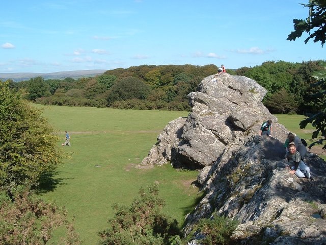
Photo: Mark Land, CC BY-SA 2.0.
Yelverton Rock is a tor-like igneous rock outcrop immediately south-west of Yelverton, Devon. It is located at the southern end of the former RAF Harrowbeer airfield on Roborough Down, next to the border with the A386.
Yelverton
Village
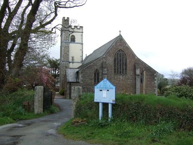
Photo: JThomas, CC BY-SA 2.0.
Yelverton is a large village on the south-western edge of Dartmoor, Devon, in England. It is in the civil parish of Buckland Monachorum. According to the 2021 census, it had a population of 1,858, which was slightly more than the 1,810 recorded at the 2011 census.
Crapstone
Village

Photo: Tony Atkin, CC BY-SA 2.0.
Crapstone is a village in the county of Devon. The village is located on the edge of Dartmoor, in the parish of Buckland Monachorum and is approximately 1 mile from the village of Yelverton, 9 miles from the city of Plymouth and 5 miles from Tavistock.
Furzedown Axtown Substation
- Type: Electrical substation
- Category: industry
- Location: Buckland Monachorum, West Devon District, Devon, West Country, England, United Kingdom, Britain and Ireland, Europe
- View on OpenStreetMap
Latitude
50.48841° or 50° 29′ 18″ northLongitude
-4.09664° or 4° 5′ 48″ westOpen location code
9C2QFWQ3+98OpenStreetMap ID
node 13234111707
This page is based on OpenStreetMap, Wikidata, and Wikimedia Commons.
We’d love your help improving our open data sources. Thank you for contributing.
Satellite Map
Discover Furzedown Axtown Substation from above in high-definition satellite imagery.
Notable Places Nearby
Highlights include Yelverton Community Park and Walkham valley scouts field.
Nearby Places
Explore places such as Knightstone Tea Rooms and Axtown Substation.
Devon: Must-Visit Destinations
Delve into Plymouth, Exeter, Torquay, and Barnstaple.
Curious Electrical Substations to Discover
Uncover intriguing electrical substations from every corner of the globe.
About Mapcarta. Data © OpenStreetMap contributors and available under the Open Database License". Text is available under the CC BY-SA 4.0 license, except for photos, directions, and the map. Photo: matthewhartley369, CC BY-SA 2.0.