X-Treme Faser
X-Treme Faser is a water slide in Erding, Upper Bavaria, Bavaria. X-Treme Faser is situated nearby to the water slide High Fly, as well as near Kamikaze.| Tap on a place to explore it |
Places of Interest Nearby
Highlights include Therme Erding and Altenerding station.
Therme Erding
Water park
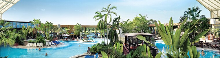
Photo: Wikimedia, CC BY-SA 3.0 de.
Therme Erding is the largest thermal bath complex in Europe, supporting a wide variety of activities. It is 30 minutes northeast of Munich by car and is visited by around 4,000 people every day. Therme Erding is situated 160 metres southwest of X-Treme Faser.
Altenerding station
Railway station
Altenerding station is a railway station in the Altenerding district of the municipality of Erding, located in the Erding district in Upper Bavaria, Germany. Altenerding station is situated 1 km east of X-Treme Faser.
St. Vitus
Church

Photo: AHert, CC BY-SA 3.0.
St. Vitus is a church, which is situated 1¼ km southwest of X-Treme Faser.
Places in the Area
Nearby places include Itzling and Heilig Blut.


X-Treme Faser
- Type: Water slide
- Categories: tourist attraction and tourism
- Location: Erding, Erding, Upper Bavaria, Bavaria, Germany, Central Europe, Europe
- View on OpenStreetMap
Latitude
48.29042° or 48° 17′ 26″ northLongitude
11.88861° or 11° 53′ 19″ eastHeight
19 metres (62 feet)Operator
Therme ErdingOpen location code
8FWH7VRQ+5COpenStreetMap ID
node 13252715336OpenStreetMap feature
attraction=water_slide
This page is based on OpenStreetMap, Wikidata, and Wikimedia Commons.
We’d love your help improving our open data sources. Thank you for contributing.
Satellite Map
Discover X-Treme Faser from above in high-definition satellite imagery.
Notable Places Nearby
Highlights include Triple Slide and High Fly.
Nearby Places
Explore places such as Royal Donuts and Physio Therm.
Upper Bavaria: Must-Visit Destinations
Delve into Munich, Ingolstadt, Rosenheim, and Dachau.
Curious Water Slides to Discover
Uncover intriguing water slides from every corner of the globe.
About Mapcarta. Data © OpenStreetMap contributors and available under the Open Database License". Text is available under the CC BY-SA 4.0 license, except for photos, directions, and the map. Photo: Wikimedia, CC BY-SA 4.0.