Triple Slide
Triple Slide is a water slide in Erding, Upper Bavaria, Bavaria. Triple Slide is situated nearby to the water slide Family SLide, as well as near High Fly.| Tap on a place to explore it |
Places of Interest Nearby
Highlights include Therme Erding and Altenerding station.
Therme Erding
Water park
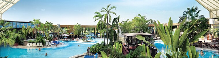
Photo: Wikimedia, CC BY-SA 3.0 de.
Therme Erding is the largest thermal bath complex in Europe, supporting a wide variety of activities. It is 30 minutes northeast of Munich by car and is visited by around 4,000 people every day. Therme Erding is situated 160 metres southwest of Triple Slide.
Altenerding station
Railway station
Altenerding station is a railway station in the Altenerding district of the municipality of Erding, located in the Erding district in Upper Bavaria, Germany. Altenerding station is situated 1 km east of Triple Slide.
St. Vitus
Church

Photo: AHert, CC BY-SA 3.0.
St. Vitus is a church, which is situated 1 km southwest of Triple Slide.
Places in the Area
Nearby places include Itzling and Heilig Blut.


Triple Slide
- Type: Water slide
- Categories: tourist attraction and tourism
- Location: Erding, Erding, Upper Bavaria, Bavaria, Germany, Central Europe, Europe
- View on OpenStreetMap
Latitude
48.29037° or 48° 17′ 25″ northLongitude
11.88871° or 11° 53′ 19″ eastHeight
2 metres (6.6 feet)Operator
Therme ErdingOpen location code
8FWH7VRQ+4FOpenStreetMap ID
node 13252825452OpenStreetMap feature
attraction=water_slide
This page is based on OpenStreetMap, Wikidata, and Wikimedia Commons.
We’d love your help improving our open data sources. Thank you for contributing.
Satellite Map
Discover Triple Slide from above in high-definition satellite imagery.
Notable Places Nearby
Highlights include High Fly and Moon, Star, Sunny Slide.
Nearby Places
Explore places such as Royal Donuts and Badhaus Gruber.
Upper Bavaria: Must-Visit Destinations
Delve into Munich, Ingolstadt, Rosenheim, and Dachau.
Curious Water Slides to Discover
Uncover intriguing water slides from every corner of the globe.
About Mapcarta. Data © OpenStreetMap contributors and available under the Open Database License". Text is available under the CC BY-SA 4.0 license, except for photos, directions, and the map. Photo: Wikimedia, CC BY-SA 4.0.