Balmore Drive
Balmore Drive is a bus stop in Reading, England. Balmore Drive is situated nearby to Caversham Preparatory School, as well as near The Chiltern College.| Tap on a place to explore it |
Places of Interest Nearby
Highlights include Reading Railway Station and Queen Anne’s School.
Reading Railway Station
Railway station
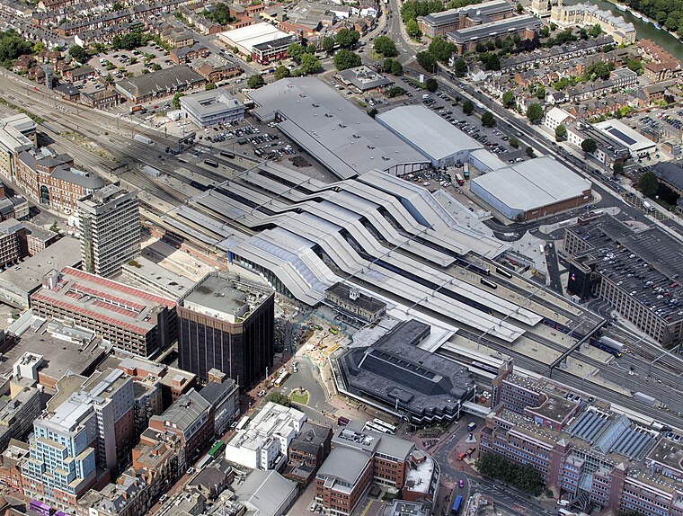
Photo: John Fielding, CC BY 2.0.
Reading railway station is a major transport hub in the town of Reading in Berkshire, England, it is 36 miles west of London Paddington. It is sited on the northern edge of the town centre, near to the main retail and commercial areas and the River Thames. Reading Railway Station is situated 1 mile south of Balmore Drive.
Queen Anne’s School
School
Queen Anne's School is a private boarding and day school for girls aged 11 to 18, situated in the suburb of Caversham just north of the River Thames and Reading town centre and occupying a 35-acre campus. Queen Anne’s School is situated 1,000 feet southeast of Balmore Drive.
Grace Church
Church

Photo: Michael Ford, CC BY-SA 2.0.
Grace Church is situated 1,900 feet northeast of Balmore Drive.
Places in the Area
Nearby places include Caversham and Emmer Green.
Caversham
Suburb

Photo: Jystyn, Public domain.
Reading is a large, historic town in Berkshire in the South East of England. It is one of the largest towns without city status in the United Kingdom with just under 235,000 inhabitants.
Emmer Green
Suburb
Photo: Andrew Smith, CC BY-SA 2.0.
Emmer Green is the northernmost suburb of Reading in Berkshire, England, centred around 2 miles north of the town centre. Having most of its own commerce, sport and other amenities, Emmer Green has an arbitrary divide with larger Caversham and a border with Oxfordshire, the county in which both places formerly stood.
Caversham Heights
Suburb

Photo: Graham Horn, CC BY-SA 2.0.
Caversham Heights is a residential area within Caversham in the borough of Reading in Berkshire, England, located to the west of the centre of Caversham.
Balmore Drive
- Type: Bus stop
- Category: transportation
- Location: Reading, England, United Kingdom, Britain and Ireland, Europe
- View on OpenStreetMap
Latitude
51.47297° or 51° 28′ 23″ northLongitude
-0.96841° or 0° 58′ 6″ westOpen location code
9C3XF2FJ+5JOpenStreetMap ID
node 13259519821OpenStreetMap feature
highway=bus_stopOpenStreetMap feature
public_transport=platform
This page is based on OpenStreetMap, Wikidata, and Wikimedia Commons.
We’d love your help improving our open data sources. Thank you for contributing.
Satellite Map
Discover Balmore Drive from above in high-definition satellite imagery.
Places with the Same Name
Discover other places named “Balmore Drive”.
Notable Places Nearby
Highlights include Caversham Preparatory School and The Chiltern College.
Nearby Places
Explore places such as Balmore Drive and Newlands Avenue.
England: Must-Visit Destinations
Delve into London, Manchester, Sheffield, and Leeds.
Curious Bus Stops to Discover
Uncover intriguing bus stops from every corner of the globe.
About Mapcarta. Data © OpenStreetMap contributors and available under the Open Database License". Text is available under the CC BY-SA 4.0 license, except for photos, directions, and the map. Photo: Wikimedia, CC BY-SA 2.0.