WSU Extension Service - Spokane
WSU Extension Service - Spokane is a government office in Spokane, Washington which is located on North Havana Street. WSU Extension Service - Spokane is situated nearby to the government office Spokane Conservation District, as well as near Avista Stadium.| Tap on a place to explore it |
Places of Interest Nearby
Highlights include Avista Stadium and Felts Field.
Avista Stadium
Stadium

Photo: Sesamehoneytart, CC BY-SA 4.0.
Avista Stadium is a baseball park in the northwest United States, located in Spokane Valley, Washington. It is the home ballpark of the Spokane Indians, a minor league baseball team in the High-A Northwest League. Avista Stadium is situated 650 feet northeast of WSU Extension Service - Spokane.
Felts Field
Aerodrome
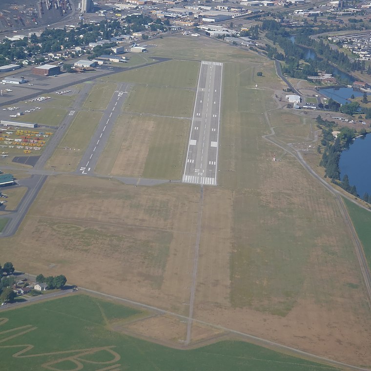
Photo: Gleby, CC BY-SA 3.0.
Felts Field is a public airport in the Northwestern United States, located five miles northeast of Downtown Spokane, in Spokane County, Washington. It is owned by Spokane City-County. Felts Field is situated 2 miles northeast of WSU Extension Service - Spokane.
Minnehaha Park
Park

Photo: Dannooll, CC BY-SA 3.0.
Minnehaha Park is a 39-acre public park located at Euclid Avenue and Havana Street in Spokane, Washington. The land for the park was acquired in 1909 but development did not begin until 1934. Minnehaha Park is situated 2 miles north of WSU Extension Service - Spokane.
Places in the Area
Nearby places include Chief Garry Park and East Central.
Chief Garry Park
Quarter
Chief Garry Park is a neighborhood in Spokane, Washington. It is located immediately south of the Spokane River. It is named for Spokane Garry and a park that has taken his name.
East Central
Quarter
East Central is a neighborhood in Spokane, Washington. As the name suggests, it is on the east side of Spokane and centrally located. The official neighborhood is expansive and covers multiple areas considered by locals to be independent neighborhoods, such… East Central is situated 1½ miles west of WSU Extension Service - Spokane.
Minnehaha
Quarter
Minnehaha is a neighborhood in Spokane, Washington, located in the northeastern portion of the city. The Spokane River flows along the southern edge of the neighborhood, from which the terrain rises along the slopes of Beacon Hill to the northeast. Minnehaha is situated 2 miles north of WSU Extension Service - Spokane.
WSU Extension Service - Spokane
- Type: Government office
- Address: 222 North Havana Street, Spokane, WA 99202
- Categories: office and government building
- Location: Spokane, Washington, Pacific Northwest, United States, North America
- View on OpenStreetMap
Latitude
47.66° or 47° 39′ 36″ northLongitude
-117.34595° or 117° 20′ 45″ westOperator
Washington State UniversityOpen location code
85V4MM63+2JOpenStreetMap ID
node 13411295054OpenStreetMap feature
office=government
This page is based on OpenStreetMap, Wikidata, and Wikimedia Commons.
We’d love your help improving our open data sources. Thank you for contributing.
Satellite Map
Discover WSU Extension Service - Spokane from above in high-definition satellite imagery.
Notable Places Nearby
Highlights include Spokane Conservation District and Union Pacific Railroad.
Nearby Places
Explore places such as Washington State University Spokane County Division and Havana @ Ferry.
Washington: Must-Visit Destinations
Delve into Seattle, Olympia, Tacoma, and Spokane.
Curious Government Offices to Discover
Uncover intriguing government offices from every corner of the globe.
About Mapcarta. Data © OpenStreetMap contributors and available under the Open Database License". Text is available under the CC BY-SA 4.0 license, except for photos, directions, and the map. Photo: Lumpytrout, CC BY-SA 3.0.