South Street
South Street is in Philadelphia, Philadelphia Region, Pennsylvania. South Street is situated nearby to the theater building Theatre of Living Arts, as well as near Kesher Israel Synagogue.| Tap on a place to explore it |
Places of Interest Nearby
Highlights include Theatre of Living Arts and Independence Hall.
Theatre of Living Arts
Theater building

Photo: Wikimedia, CC BY-SA 3.0.
The Theatre of Living Arts is a concert venue that is located on South Street in Philadelphia, Pennsylvania. The venue, which opened in 1988, dates back to the early 1900s as a nickelodeon.
Independence Hall
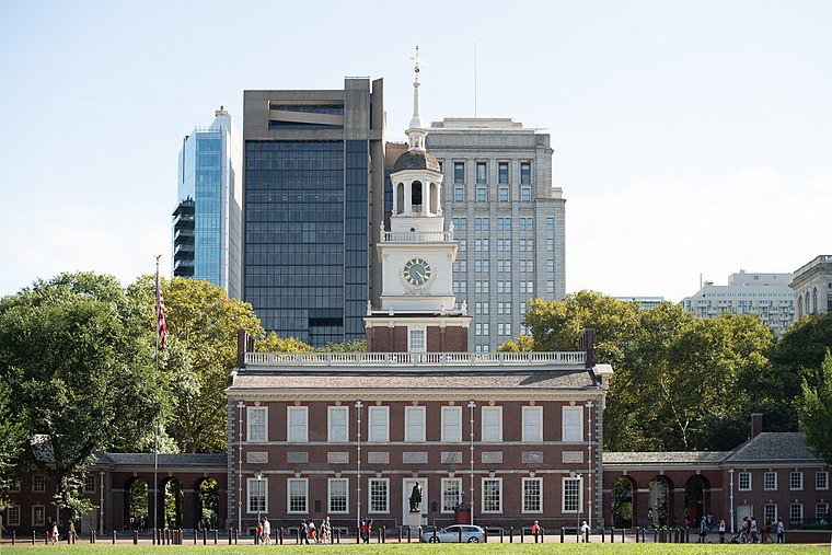
Photo: Mys 721tx, CC BY-SA 3.0.
Independence Hall is a historic civic building in Philadelphia, Pennsylvania, where both the Declaration of Independence and the Constitution of the United States were debated and adopted by the Founding Fathers of the United States. Independence Hall is situated 2,500 feet north of South Street.
Liberty Bell

Photo: tonythemisfit, CC BY 2.0.
The Liberty Bell, previously called the State House Bell or Old State House Bell, is an iconic symbol of American independence located in Philadelphia. Liberty Bell is situated 2,700 feet north of South Street.
Places in the Area
Nearby places include Society Hill and Queen Village.
Society Hill
Neighborhood

Photo: Smallbones, Public domain.
Society Hill is a historic neighborhood in Center City, Philadelphia, Pennsylvania, United States, with a population of 6,215 as of the 2010 United States census.
Queen Village
Neighborhood

Photo: Beyond My Ken, CC BY-SA 4.0.
Queen Village is a residential neighborhood of Philadelphia, Pennsylvania, United States that lies along the eastern edge of the city in South Philadelphia.
Old City

Photo: Beyond My Ken, CC BY-SA 3.0.
Philadelphia's Old City is home to many historical sites, galleries, restaurants, and bars. It is known for its active nightlife and cultural opportunities.
South Street
- Type: Carsharing
- Category: transportation
- Location: Philadelphia, Philadelphia, Philadelphia Region, Pennsylvania, Mid-Atlantic, United States, North America
- View on OpenStreetMap
Latitude
39.94201° or 39° 56′ 31″ northLongitude
-75.14904° or 75° 8′ 57″ westOperator
Enterprise HoldingsOpen location code
87F6WVR2+R9OpenStreetMap ID
node 1590298712OpenStreetMap feature
amenity=car_sharing
This page is based on OpenStreetMap, Wikidata, and Wikimedia Commons.
We’d love your help improving our open data sources. Thank you for contributing.
Satellite Map
Discover South Street from above in high-definition satellite imagery.
Places with the Same Name
Discover other places named “South Street”.
Notable Places Nearby
Highlights include Kesher Israel Synagogue and United States Post Office.
Nearby Places
Explore places such as The Foremost and Milk and Honey Cafe.
Philadelphia: Must-Visit Destinations
Delve into Philadelphia International Airport, Old City, West Philadelphia, and Center City West.
Curious Places to Discover
Uncover intriguing places from every corner of the globe.
About Mapcarta. Data © OpenStreetMap contributors and available under the Open Database License". Text is available under the CC BY-SA 4.0 license, except for photos, directions, and the map. Photo: Dave Z, CC BY 2.0.