Darun Nimit
Darun Nimit is a kindergarten in Chang Khlan, Mueang Chiang Mai, Chiang Mai Province. Darun Nimit is situated nearby to Chiangmai Commercial Technology College, as well as near Nakornping Hospital Outpatient Department.| Tap on a place to explore it |
Places of Interest Nearby
Highlights include Wat Saimoonmuang and Wat Sai Moon Myanmar.
Wat Saimoonmuang
Buddhist temple

Photo: DerFussi, CC BY-SA 3.0.
Wat Saimoonmuang is a Buddhist temple, which is situated 290 metres west of Darun Nimit.
Wat Sai Moon Myanmar
Buddhist temple
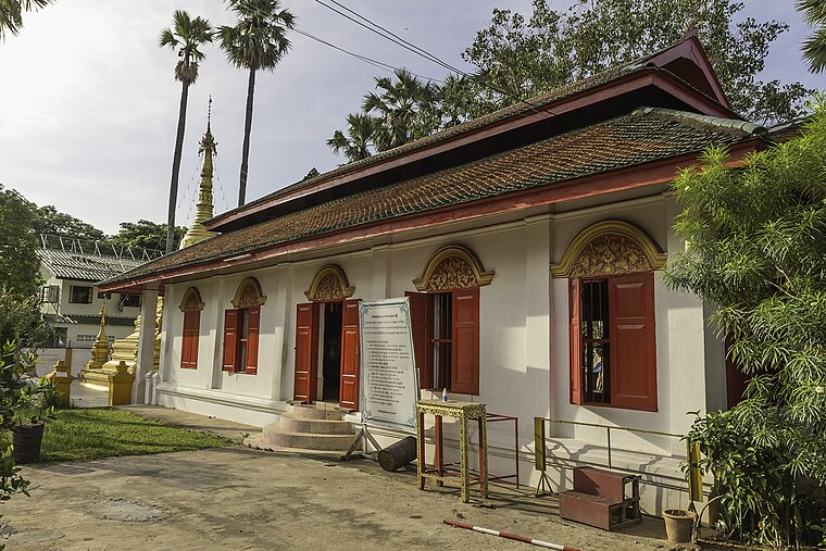
Photo: DerFussi, CC BY-SA 3.0.
Wat Sai Moon Myanmar is a Buddhist temple, which is situated 420 metres west of Darun Nimit.
Wat Chedi Luang
Buddhist temple
 Wat Chedi Luang is a Buddhist temple in the historic centre of Chiang Mai, Thailand. The current temple grounds were originally made up of three temples — Wat Chedi Luang, Wat Ho Tham and Wat Sukmin. Wat Chedi Luang is situated 1 km northwest of Darun Nimit.
Places in the Area
Nearby places include Chiang Mai and Nong Hoi.
Chiang Mai

Photo: Tevaprapas, CC BY 3.0.
Chiang Mai is the hub of northern Thailand. On a plain at an elevation of 316 m, surrounded by mountains and lush countryside, it is much greener and quieter than the capital and has a cosmopolitan air and a significant expatriate population, all factors which have led many from Bangkok to settle permanently in this "rose of the north".
Nong Hoi
Town
Nong Hoi is a tambon of Mueang Chiang Mai District, in Chiang Mai Province, Thailand. In 2005 it had a population of 13,144 people. The tambon contains six villages. Nong Hoi is situated 3 km southeast of Darun Nimit.
Nong Pa Khrang
Town
Nong Pa Khrang is a tambon of Mueang Chiang Mai District, in Chiang Mai Province, Thailand. In 2005 it had a population of 8,423 people. The tambon contains seven mubans. Nong Pa Khrang is situated 3½ km east of Darun Nimit.
Darun Nimit
- Type: Kindergarten
- Category: education
- Location: Chang Khlan, Mueang Chiang Mai, Chiang Mai Province, Northern Thailand, Thailand, Southeast Asia, Asia
- View on OpenStreetMap
Latitude
18.78228° or 18° 46′ 56″ northLongitude
98.99519° or 98° 59′ 43″ eastOpen location code
7MCWQXJW+W3OpenStreetMap ID
node 1618793906OpenStreetMap feature
amenity=kindergarten
This page is based on OpenStreetMap, Wikidata, and Wikimedia Commons.
We’d love your help improving our open data sources. Thank you for contributing.
Satellite Map
Discover Darun Nimit from above in high-definition satellite imagery.
In Other Languages
“Darun Nimit” goes by many names.
- Thai: “โรงเรียนอนุบาลดรุณนิมิต”
Notable Places Nearby
Highlights include Chiangmai Commercial Technology College and Nakornping Hospital Outpatient Department.
Nearby Places
Explore places such as Bed And Terrace Guesthouse Chiang Mai and Hawaiian Son.
Chiang Mai Province: Must-Visit Destinations
Delve into Chiang Mai, Samoeng, Chiang Dao, and Doi Inthanon National Park.
Curious Kindergartens to Discover
Uncover intriguing kindergartens from every corner of the globe.
About Mapcarta. Data © OpenStreetMap contributors and available under the Open Database License". Text is available under the CC BY-SA 4.0 license, except for photos, directions, and the map. Photo: Gudesign, CC BY-SA 3.0.