Tom’s Car Station
Tom’s Car Station is a car dealership in Lübeck, Hansestadt, Lübeck, Schleswig-Holstein. Tom’s Car Station is situated nearby to the church Freie Christengemeinde AGAPE, as well as near the playground Artlenburger Straße.| Tap on a place to explore it |
Places of Interest Nearby
Highlights include Holstentor and Lübeck Hauptbahnhof.
Holstentor
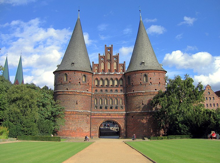
Photo: gds, CC BY-SA 2.0.
The Holsten Gate is a city gate marking off the western boundary of the old center of the Hanseatic city of Lübeck. Built in 1464, the Brick Gothic construction is one of the relics of Lübeck's medieval city fortifications and one of two remaining city gates, the other being the Citadel Gate. Holstentor is situated 1½ km southeast of Tom’s Car Station.
Lübeck Hauptbahnhof
Railway station

Photo: 1970gemini, CC BY-SA 3.0.
Lübeck Hauptbahnhof is the main railway station serving the Hanseatic city of Lübeck, in the German state of Schleswig-Holstein. It is a through station at the western edge of the city centre. Lübeck Hauptbahnhof is situated 800 metres southeast of Tom’s Car Station.
Stolperstein dedicated to Erich Klann
Memorial

Photo: JanTappenbeck, CC BY-SA 3.0.
Stolperstein dedicated to Erich Klann is a memorial, which is situated 220 metres southeast of Tom’s Car Station.
Places in the Area
Nearby places include Stockelsdorf and Moisling.
Stockelsdorf
Town

Photo: Genet, CC BY-SA 3.0.
Stockelsdorf is a municipality in the district of Ostholstein, in Schleswig-Holstein, Germany. It is situated directly northwest of Lübeck and forms an agglomeration with the easterly town of Bad Schwartau. Stockelsdorf is situated 3 km north of Tom’s Car Station.
Moisling
Suburb

Photo: MrsMyerDE, CC BY-SA 3.0.
Moisling is a suburb, which is situated 4 km southwest of Tom’s Car Station.
Badendorf
Village
Badendorf is a municipality in the district of Stormarn, in Schleswig-Holstein, Germany. Badendorf is situated 6 km west of Tom’s Car Station.
Tom’s Car Station
- Opening hours: Monday—Friday 9:00 AM—6:00 PM
- Type: Car dealership
- Categories: shop and transportation
- Location: Lübeck, Hansestadt, Lübeck, East Holstein, Schleswig-Holstein, Germany, Central Europe, Europe
- View on OpenStreetMap
Latitude
53.87208° or 53° 52′ 20″ northLongitude
10.66026° or 10° 39′ 37″ eastOpen location code
9F5GVMC6+R4OpenStreetMap ID
node 1762750268OpenStreetMap feature
shop=car
This page is based on OpenStreetMap, Wikidata, and Wikimedia Commons.
We’d love your help improving our open data sources. Thank you for contributing.
Satellite Map
Discover Tom’s Car Station from above in high-definition satellite imagery.
Notable Places Nearby
Highlights include Freie Christengemeinde AGAPE and Artlenburger Straße.
Nearby Places
Explore places such as H. Junghans and HairGuide.
East Holstein: Must-Visit Destinations
Delve into Fehmarn, Ratzeburg, Timmendorfer Strand, and Grömitz.
Curious Car Dealerships to Discover
Uncover intriguing car dealerships from every corner of the globe.
About Mapcarta. Data © OpenStreetMap contributors and available under the Open Database License". Text is available under the CC BY-SA 4.0 license, except for photos, directions, and the map. Photo: Wikimedia, CC0.