Cerro Millantuy
Cerro Millantuy is a scenic viewpoint in Los Lagos, Southern Chile. Cerro Millantuy is situated nearby to the church Virgen, as well as near the park Parque Millantuy.| Tap on a place to explore it |
Places of Interest Nearby
Highlights include Church of San Francisco and Gamboa Airport.
Church of San Francisco
Church
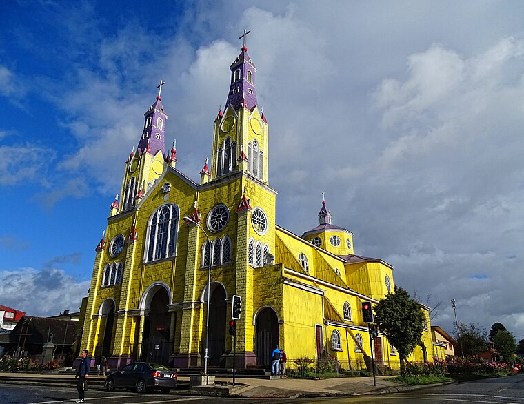
Photo: Uspn, CC BY-SA 4.0.
The Church of San Francisco, located on one side of the Plaza de Armas of Castro, Chile, is the main Catholic church of Chiloé’s capital. This 1912 building has a surface area of 1,404 m2, a width of 52 m and a height of 27 m. Church of San Francisco is situated 800 metres southeast of Cerro Millantuy.
Gamboa Airport
Aerodrome
Gamboa Airport is an airport serving Castro, a city on Chiloé Island in the Los Lagos Region of Chile. The airport runs along the shoreline just south of Gamboa, and south approach and departures are over the water.
Church of Nercón
Church

Photo: Rjcastillo, CC BY-SA 4.0.
The Church of Nercón —Spanish: Iglesia de Señora de Gracia de Nercón— is a UNESCO World Heritage Site. It is a Church on the Chiloé Island in Chiloé, Chile. Church of Nercón is situated 3 km southwest of Cerro Millantuy.
Places in the Area
Nearby places include Castro.
Castro

Photo: Draceane, CC BY-SA 4.0.
Castro is the capital of Chiloé Island. It is a city of 42,000 people on the island's eastern coast, halfway between Ancud in the north and Quellon in the south, and is a convenient base for exploring the island of Chiloe.
Cerro Millantuy
- Type: Scenic viewpoint
- Category: tourism
- Location: Los Lagos, Southern Chile, Chile, South America
- View on OpenStreetMap
Latitude
-42.47671° or 42° 28′ 36″ southLongitude
-73.77114° or 73° 46′ 16″ westOpen location code
4798G6FH+8GOpenStreetMap ID
node 1777131476OpenStreetMap feature
tourism=viewpoint
This page is based on OpenStreetMap, Wikidata, and Wikimedia Commons.
We’d love your help improving our open data sources. Thank you for contributing.
Satellite Map
Discover Cerro Millantuy from above in high-definition satellite imagery.
Notable Places Nearby
Highlights include Virgen and Parque Millantuy.
Nearby Places
Explore places such as Cerro Millantuy and Liceo Técnico Profesional Gabriela Mistral.
Los Lagos: Must-Visit Destinations
Delve into Puerto Montt, Puerto Varas, Chaitén, and Frutillar.
Curious Scenic Viewpoints to Discover
Uncover intriguing scenic viewpoints from every corner of the globe.
About Mapcarta. Data © OpenStreetMap contributors and available under the Open Database License". Text is available under the CC BY-SA 4.0 license, except for photos, directions, and the map. Photo: Draceane, CC BY-SA 4.0.