Schutzhütte Wilhelmshöhe
Schutzhütte Wilhelmshöhe is a shelter in Cochem, Moselle Valley, Rhineland-Palatinate. Schutzhütte Wilhelmshöhe is situated nearby to the scenic viewpoint Winneburgblick, as well as near the ruins Bergfried.| Tap on a place to explore it |
Places of Interest Nearby
Highlights include Wild- und Freizeitpark Klotten and Enderttor.
Wild- und Freizeitpark Klotten
Theme park

Photo: Wolkenkratzer, CC BY-SA 4.0.
Wild- und Freizeitpark Klotten is a theme park, which is situated 1½ km northeast of Schutzhütte Wilhelmshöhe.
Enderttor
City gate
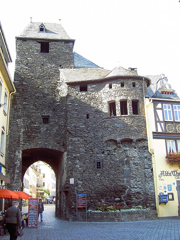 Enderttor is a city gate, which is situated 1½ km east of Schutzhütte Wilhelmshöhe.
Bahnhof Cochem
Railway station

Photo: Historiograf, CC BY 2.0.
Bahnhof Cochem is a railway station, which is situated 1½ km east of Schutzhütte Wilhelmshöhe.
Places in the Area
Nearby places include Winneburg and Cochem Castle.


Faid
Village

Photo: Reinhardhauke, CC BY-SA 3.0.
Faid is an Ortsgemeinde – a municipality belonging to a Verbandsgemeinde, a kind of collective municipality – in the Cochem-Zell district in Rhineland-Palatinate, Germany. It belongs to the Verbandsgemeinde of Cochem, whose seat is in the like-named town.
Schutzhütte Wilhelmshöhe
- Type: Shelter
- Wheelchair access: yes
- Location: Cochem, Cochem-Zell, Moselle Valley, Rhineland-Palatinate, Germany, Central Europe, Europe
- View on OpenStreetMap
Latitude
50.15122° or 50° 9′ 4″ northLongitude
7.1467° or 7° 8′ 48″ eastOpen location code
9F29542W+FMOpenStreetMap ID
node 1842798131OpenStreetMap feature
amenity=shelterOpenStreetMap attribute
wheelchair=yes
This page is based on OpenStreetMap, Wikidata, and Wikimedia Commons.
We’d love your help improving our open data sources. Thank you for contributing.
Satellite Map
Discover Schutzhütte Wilhelmshöhe from above in high-definition satellite imagery.
Notable Places Nearby
Highlights include Wilhelmshöhe and Winneburgblick.
Nearby Places
Explore places such as Winzerhaus and Cochem Wakelei.
Moselle Valley: Must-Visit Destinations
Delve into Trier, Konz, Traben-Trarbach, and Treis-Karden.
Curious Shelters to Discover
Uncover intriguing shelters from every corner of the globe.
About Mapcarta. Data © OpenStreetMap contributors and available under the Open Database License". Text is available under the CC BY-SA 4.0 license, except for photos, directions, and the map. Photo: Michal Osmenda, CC BY-SA 2.0.