Ghlin
Ghlin is a railway stop in Mons, Hainaut, Wallonia. Ghlin is situated nearby to the church Chapelle Notre-Dame du Mouligneau, as well as near Chapelle Notre-Dame de Tongres.| Tap on a place to explore it |
Places of Interest Nearby
Highlights include Ghlin railway station and Ghlin Communal Cemetery.
Ghlin railway station
Railway stop
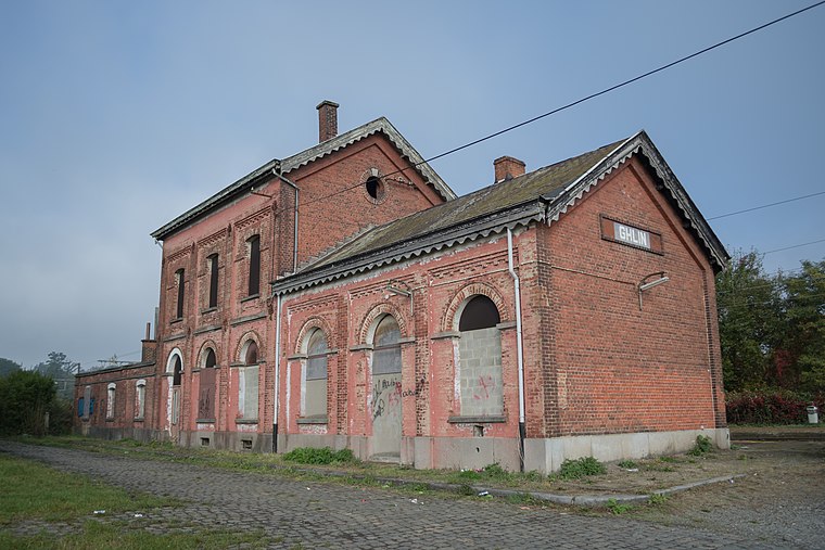
Photo: RomainDil, CC BY-SA 4.0.
Ghlin railway station is a railway stop.
Ghlin Communal Cemetery
Cemetery

Photo: Wernervc, CC BY-SA 4.0.
Ghlin Communal Cemetery is situated 1¼ km southwest of Ghlin.
Hippodrome de Wallonie
Sports venue
Hippodrome de Wallonie is a horse racing venue located in Mons, Wallonia, Belgium. Hippodrome de Wallonie is situated 1½ km southeast of Ghlin.
Places in the Area
Nearby places include Ghlin and Nimy.
Ghlin
Village
 Ghlin is a sub-municipality of the city of Mons located in the province of Hainaut, Wallonia, Belgium. It was a separate municipality until 1972. On 1 January 1972, it was merged into Mons.
Nimy
Village
Nimy is a sub-municipality of the city of Mons located in the province of Hainaut, Wallonia, Belgium. It was a separate municipality until 1972. On 1 January 1972, it was merged into Mons. Nimy is situated 3½ km east of Ghlin.
Maisières
Village

Photo: Jean-Pol GRANDMONT, CC BY 3.0.
Maisières is a sub-municipality of the city of Mons located in the province of Hainaut, Wallonia, Belgium. It was a separate municipality until 1977. On 1 January 1977, it was merged into Mons. Maisières is situated 4 km east of Ghlin.
Ghlin
- Type: Railway stop
- Categories: transport stop and transportation
- Location: Mons, Arrondissement of Mons, Hainaut, Wallonia, Belgium, Benelux, Europe
- View on OpenStreetMap
Latitude
50.4875° or 50° 29′ 15″ northLongitude
3.90635° or 3° 54′ 23″ eastOpen location code
9F25FWQ4+2GOpenStreetMap ID
node 1867686436OpenStreetMap feature
public_transport=stop_positionOpenStreetMap feature
railway=stop
This page is based on OpenStreetMap, Wikidata, and Wikimedia Commons.
We’d love your help improving our open data sources. Thank you for contributing.
Satellite Map
Discover Ghlin from above in high-definition satellite imagery.
In Other Languages
“Ghlin” goes by many names.
- Dutch: “Ghlin”
Places with the Same Name
Discover other places named “Ghlin”.
Notable Places Nearby
Highlights include Gare de Ghlin and Chapelle Notre-Dame du Mouligneau.
Nearby Places
Explore places such as Ghlin and Detandt-Simon.
Hainaut: Must-Visit Destinations
Delve into Charleroi, Tournai, La Louvière, and Binche.
Curious Railway Stops to Discover
Uncover intriguing railway stops from every corner of the globe.
About Mapcarta. Data © OpenStreetMap contributors and available under the Open Database License". Text is available under the CC BY-SA 4.0 license, except for photos, directions, and the map. Photo: Jean-Pol GRANDMONT, CC BY-SA 3.0.