Oficina de Correos
Oficina de Correos is a post office in Madrid, Community of Madrid which is located on Calle de Antonio Arias. Oficina de Correos is situated nearby to the church Parroquia de San Vicente Ferrer, as well as near the park Senda botánica Hospital Gregorio Marañón.| Tap on a place to explore it |
- Opening hours:
Monday—Friday: 8:30 AM—8:30 PM
Saturday: 9:30 AM—1:00 PM
August: Monday—Friday 8:30 AM—2:30 PM; Saturday 9:30 AM—1:00 PM
December 24th, December 31st, January 1st, and January 6th: closed
public holidays: closed - Email: suc21.madrid@correos.es
- Type: Post office
- Address: Calle de Antonio Arias 2, Madrid, 28009
- Wheelchair access: yes
Places of Interest Nearby
Highlights include Hospital General Universitario Gregorio Marañón and Palacio de Deportes de la Comunidad de Madrid.
Hospital General Universitario Gregorio Marañón
Hospital

Photo: Israel Hergón, CC BY-SA 2.0.
The Hospital General Universitario Gregorio Marañón is a public general hospital located at the neighborhood of Ibiza in Madrid, Spain, part of the hospital network of the Servicio Madrileño de Salud. Hospital General Universitario Gregorio Marañón is situated 200 metres north of Oficina de Correos.
Palacio de Deportes de la Comunidad de Madrid
Stadium

Photo: Zaqarbal, CC BY-SA 3.0 es.
Sports Palace of the Community of Madrid or simply Madrid Sports Palace, officially Movistar Arena since January 2025 for sponsorship reasons, is an indoor sporting arena located in Madrid, Spain. Palacio de Deportes de la Comunidad de Madrid is situated 670 metres north of Oficina de Correos.
Biblioteca Nacional de España
Library
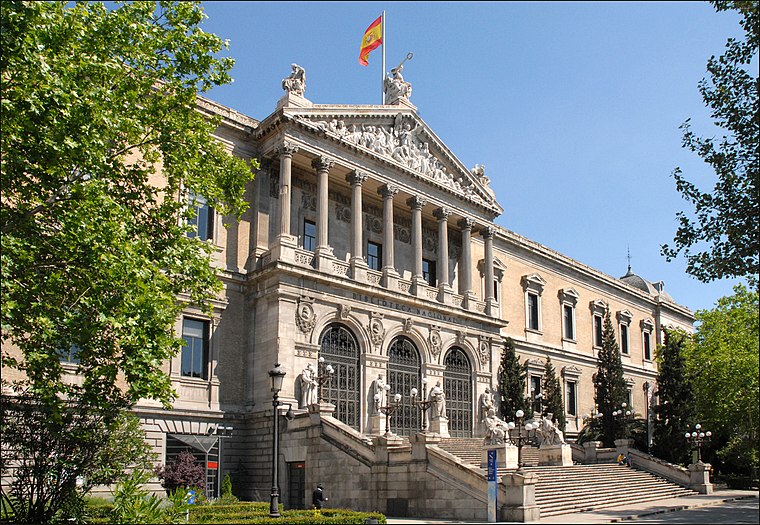 The Biblioteca Nacional de España is the national library of Spain. It is the largest public library in the country, and one of the largest in the world. Biblioteca Nacional de España is situated 1½ km northwest of Oficina de Correos.
Places in the Area
Nearby places include Ibiza and Niño Jesús.
Ibiza
Quarter

Photo: Wikimedia, CC BY-SA 3.0.
Ibiza is an administrative neighborhood of Madrid belonging to the district of Retiro. It has an area of 0.490863 km2. As of 1 February 2020, it has a population of 22,050.
Niño Jesús
Quarter

Photo: Ricardo Ricote Rodrí…, CC BY 3.0.
Niño Jesús is an administrative neighborhood of Madrid belonging to the district of Retiro. It is 0.643202 km² in size.
Estrella
Quarter
Estrella is an administrative neighborhood of Madrid belonging to the district of Retiro. It has an area of 1.025805 km2. As of 1 March 2020, it has a population of 23,474.
Oficina de Correos
- Location: Madrid, Madrid, Community of Madrid, Central Spain, Spain, Iberia, Europe
- View on OpenStreetMap
Latitude
40.41786° or 40° 25′ 4″ northLongitude
-3.67158° or 3° 40′ 18″ westOpen location code
8CGRC89H+49OpenStreetMap ID
node 1888551195OpenStreetMap feature
amenity=post_officeOpenStreetMap attribute
wheelchair=yes
This page is based on OpenStreetMap, Wikidata, and Wikimedia Commons.
We’d love your help improving our open data sources. Thank you for contributing.
Satellite Map
Discover Oficina de Correos from above in high-definition satellite imagery.
In Other Languages
“Oficina de Correos” goes by many names.
- Spanish: “Oficina de Correos”
Places with the Same Name
Discover other places named “Oficina de Correos”.
Notable Places Nearby
Highlights include Parroquia de San Vicente Ferrer and Senda botánica Hospital Gregorio Marañón.
Nearby Places
Explore places such as Bar Cafeteria Alemar and Burger King.
Madrid: Must-Visit Destinations
Delve into Sol-Letras-Lavapiés, Salamanca, Retiro-Paseo del Arte, and Chamberí-Castellana.
Curious Post Offices to Discover
Uncover intriguing post offices from every corner of the globe.
About Mapcarta. Data © OpenStreetMap contributors and available under the Open Database License". Text is available under the CC BY-SA 4.0 license, except for photos, directions, and the map. Photo: DonPaolo, CC BY-SA 3.0.