Farmacia del Niño Jesús
Farmacia del Niño Jesús is a pharmacy in Retiro, Madrid, Community of Madrid which is located on Calle del Doce de Octubre. Farmacia del Niño Jesús is situated nearby to the health club Instituto Zentro, as well as near the police station Comisaría de Policía.| Tap on a place to explore it |
- Type: Pharmacy
- Also known as: “Farmacia Pacheco Sánchez-Brunete”
- Address: Calle del Doce de Octubre 2, Madrid, 28009
Places of Interest Nearby
Highlights include Hospital del Niño Jesús and Palacio de Cristal del Retiro.
Hospital del Niño Jesús
Hospital

Photo: Wikimedia, Public domain.
The Hospital Infantil Universitario Niño Jesús is a children's hospital located at the Niño Jesús neighborhood in Madrid, Spain, part of the hospital network of the Servicio Madrileño de Salud. The building was declared Bien de Interés Cultural in 1995. Hospital del Niño Jesús is situated 160 metres southeast of Farmacia del Niño Jesús.
Palacio de Cristal del Retiro
Arts center

Photo: Wikimedia, CC BY-SA 2.0.
The Palacio de Cristal is a 19th-century conservatory located in the Buen Retiro Park in Madrid, Spain. It is currently used for art exhibitions. The Palacio de Cristal, in the shape of a Greek cross, is made almost entirely of glass set in an iron framework on a brick base, which is decorated with ceramics. Palacio de Cristal del Retiro is situated 450 metres southwest of Farmacia del Niño Jesús.
Biblioteca Nacional de España
Library
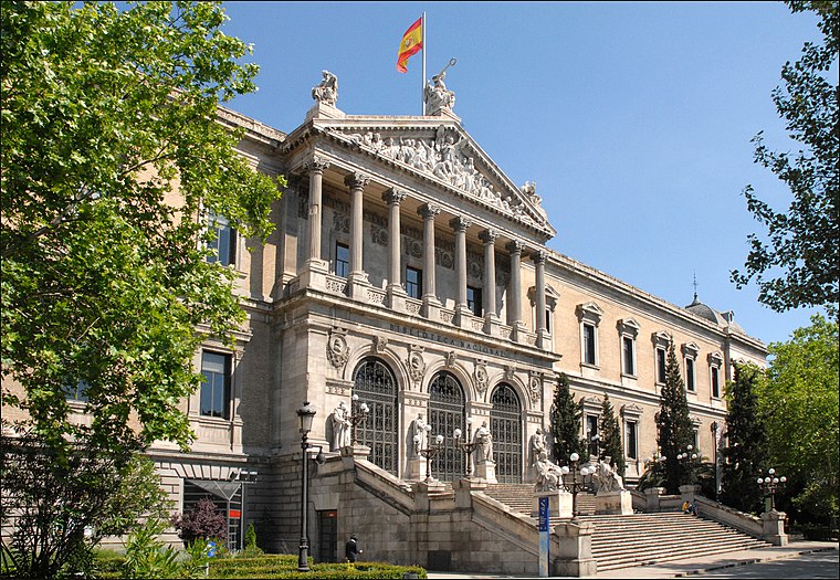 The Biblioteca Nacional de España is the national library of Spain. It is the largest public library in the country, and one of the largest in the world. Biblioteca Nacional de España is situated 1½ km northwest of Farmacia del Niño Jesús.
Places in the Area
Nearby places include Retiro-Paseo del Arte and Ibiza.
Retiro-Paseo del Arte
 Retiro is a district in eastern-central Madrid. While it is dominated by the Retiro Park, it also houses 125,000 residents. This article also includes the Paseo del Arte where the city's most famous art museums are lined up.
Ibiza
Quarter

Photo: Wikimedia, CC BY-SA 3.0.
Ibiza is an administrative neighborhood of Madrid belonging to the district of Retiro. It has an area of 0.490863 km2. As of 1 February 2020, it has a population of 22,050.
Niño Jesús
Quarter

Photo: Ricardo Ricote Rodrí…, CC BY 3.0.
Niño Jesús is an administrative neighborhood of Madrid belonging to the district of Retiro. It is 0.643202 km² in size.
Farmacia del Niño Jesús
- Category: health care
- Location: Retiro, Madrid, Madrid, Community of Madrid, Central Spain, Spain, Iberia, Europe
- View on OpenStreetMap
Latitude
40.41543° or 40° 24′ 56″ northLongitude
-3.67734° or 3° 40′ 38″ westOpen location code
8CGRC88F+53OpenStreetMap ID
node 1889602495OpenStreetMap feature
amenity=pharmacyOpenStreetMap feature
healthcare=pharmacy
This page is based on OpenStreetMap, Wikidata, and Wikimedia Commons.
We’d love your help improving our open data sources. Thank you for contributing.
Satellite Map
Discover Farmacia del Niño Jesús from above in high-definition satellite imagery.
Notable Places Nearby
Highlights include Instituto Zentro and Comisaría de Policía.
Nearby Places
Explore places such as Piloto II and Autoescuela Retiro.
Madrid: Must-Visit Destinations
Delve into Sol-Letras-Lavapiés, Salamanca, Retiro-Paseo del Arte, and Chamberí-Castellana.
Curious Pharmacies to Discover
Uncover intriguing pharmacies from every corner of the globe.
About Mapcarta. Data © OpenStreetMap contributors and available under the Open Database License". Text is available under the CC BY-SA 4.0 license, except for photos, directions, and the map. Photo: DonPaolo, CC BY-SA 3.0.