Jandel’s Beach Cafe
Jandel’s Beach Cafe is a café in Torrevieja, Costa Blanca, Valencian Community. Jandel’s Beach Cafe is situated nearby to Torre de La Mata, as well as near the church Parroquia Nuestra Señora del Rosario.| Tap on a place to explore it |
Places of Interest Nearby
Highlights include Torre de La Mata and Cervera Tower.
Torre de La Mata
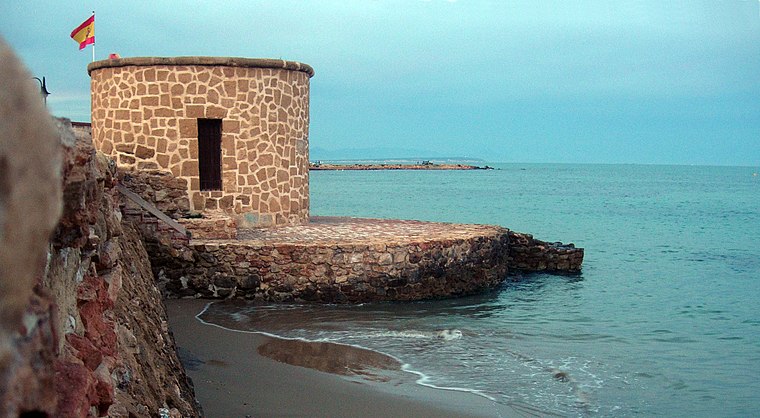
Photo: Polosureste, CC BY 3.0.
Torre de La Mata is situated 130 metres south of Jandel’s Beach Cafe.
Cervera Tower
Castle
 Cervera Tower is a castle, which is situated 3 km south of Jandel’s Beach Cafe.
Laguna de La Mata

Photo: Javier martinlo, CC BY-SA 3.0 es.
Laguna de La Mata is situated 3½ km west of Jandel’s Beach Cafe.
Places in the Area
Nearby places include Torre La Mata and Guardamar del Segura.
Torre La Mata
Village
Torre La Mata or simply La Mata is a district of Torrevieja located 5 km northeast of the city along the Costa Blanca, in the province of Alicante in southeast Spain.
Guardamar del Segura
Town
Photo: Toniher, CC BY-SA 3.0.
Guardamar del Segura, or briefly Guardamar, is a municipality of the province of Alicante located at the mouth of the river Segura in southern Valencia, Spain. Guardamar del Segura is situated 7 km north of Jandel’s Beach Cafe.
Quesada
Suburb
 Ciudad Quesada is a district in the municipality of Rojales in the Province of Alicante, Spain. It has a population of 16,583 people. It is located in the southern area of Rojales, 6 km from Mediterranean sea. Quesada is situated 7 km northwest of Jandel’s Beach Cafe.
Jandel’s Beach Cafe
- Type: Café
- Location: Torrevieja, Costa Blanca, Alicante, Valencian Community, Eastern Spain, Spain, Iberia, Europe
- View on OpenStreetMap
Latitude
38.02755° or 38° 1′ 39″ northLongitude
-0.65264° or 0° 39′ 10″ westOpen location code
8CCX28HW+2WOpenStreetMap ID
node 2110796823OpenStreetMap feature
amenity=cafe
This page is based on OpenStreetMap, Wikidata, and Wikimedia Commons.
We’d love your help improving our open data sources. Thank you for contributing.
Satellite Map
Discover Jandel’s Beach Cafe from above in high-definition satellite imagery.
Notable Places Nearby
Highlights include Parroquia Nuestra Señora del Rosario and Plaza Encarnación Puchol.
Nearby Places
Explore places such as El Pescador and Fruteria.
Costa Blanca: Must-Visit Destinations
Delve into Alicante, Elche, Benidorm, and Dénia.
Curious Cafés to Discover
Uncover intriguing cafés from every corner of the globe.
About Mapcarta. Data © OpenStreetMap contributors and available under the Open Database License". Text is available under the CC BY-SA 4.0 license, except for photos, directions, and the map. Photo: baloun, CC BY-SA 3.0.