Hinterm Schloß
Hinterm Schloß is a dwelling in Staufen im Breisgau, Breisgau-Hochschwarzwald, Baden-Württemberg. Hinterm Schloß is situated nearby to the church Magdalenenkapelle, as well as near the scenic viewpoint Burg Staufen.| Tap on a place to explore it |
Places of Interest Nearby
Highlights include Magdalenenkapelle and Staufen railway station.
Magdalenenkapelle
Church

Photo: Joergens.mi, CC BY-SA 3.0.
Magdalenenkapelle is a church, which is situated 450 metres west of Hinterm Schloß.
Staufen railway station
Railway station

Photo: Smiley.toerist, CC BY-SA 4.0.
Staufen railway station is situated 670 metres southwest of Hinterm Schloß.
Rathaus
Town hall

Photo: Andreas Schwarzkopf, CC BY-SA 3.0.
Rathaus is a town hall, which is situated 1 km south of Hinterm Schloß.
Places in the Area
Nearby places include Bad Krozingen and Tunsel.
Bad Krozingen
Town
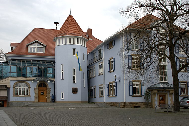
Photo: Ireas, CC BY-SA 4.0.
Bad Krozingen is a spa town in the district Breisgau-Hochschwarzwald, in Baden-Württemberg, Germany. It is situated 15 km southwest of Freiburg. In the 1970s, the previously independent villages Biengen, Hausen an der Möhlin, Schlatt and Tunsel, including Schmidhofen, became part of Bad Krozingen. Bad Krozingen is situated 3½ km northwest of Hinterm Schloß.
Tunsel
Village
Tunsel is a village in the district of Breisgau-Hochschwarzwald in Baden-Württemberg. Since January 1974, it is an Ortsteil of Bad Krozingen. Tunsel is situated 5 km west of Hinterm Schloß.
Münstertal, Black Forest
Village

Photo: Taxiarchos228, CC BY-SA 2.0 de.
Münstertal is a municipality in the southern Black Forest, which belongs to the district of Breisgau-Hochschwarzwald in Baden-Württemberg in southern Germany. It is 3 miles east from Staufen. Münstertal, Black Forest is situated 5 km southeast of Hinterm Schloß.
Hinterm Schloß
- Type: Dwelling
- Categories: locality, residential building, and building
- Location: Staufen im Breisgau, Breisgau-Hochschwarzwald, Freiburg Region, Baden-Württemberg, Germany, Central Europe, Europe
- View on OpenStreetMap
Latitude
47.89° or 47° 53′ 24″ northLongitude
7.73408° or 7° 44′ 3″ eastOpen location code
8FV9VPRM+2JOpenStreetMap ID
node 2499243879OpenStreetMap feature
place=isolated_dwelling
This page is based on OpenStreetMap, Wikidata, and Wikimedia Commons.
We’d love your help improving our open data sources. Thank you for contributing.
Satellite Map
Discover Hinterm Schloß from above in high-definition satellite imagery.
Places with the Same Name
Discover other places named “Hinterm Schloß”.
Notable Places Nearby
Highlights include Burg Staufen and Sonnenhof.
Nearby Places
Explore places such as Obstbaumpfad Staufen 4 and Staufen Burgruine.
Baden-Württemberg: Must-Visit Destinations
Delve into Stuttgart, Heidelberg, Karlsruhe, and Mannheim.
Curious Dwellings to Discover
Uncover intriguing dwellings from every corner of the globe.
About Mapcarta. Data © OpenStreetMap contributors and available under the Open Database License". Text is available under the CC BY-SA 4.0 license, except for photos, directions, and the map. Photo: Traveler100, CC BY-SA 3.0.