Aparcamiento Municipal Vallobín
Aparcamiento Municipal Vallobín is a parking area in Asturias, Green Spain. Aparcamiento Municipal Vallobín is situated nearby to the work of art Monument to Victims of Terrorism (1968–2007), as well as near the park Plaza Ángel González.| Tap on a place to explore it |
Places of Interest Nearby
Highlights include Monument to Victims of Terrorism (1968–2007) and Estadio Carlos Tartiere.
Monument to Victims of Terrorism (1968–2007)
Work of art

Photo: Adolfobrigido, CC BY-SA 4.0.
Monument to Victims of Terrorism (1968–2007) is a work of art.
Estadio Carlos Tartiere
Stadium
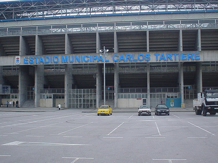
Photo: Rsg, CC BY-SA 2.5 es.
Estadio Municipal Carlos Tartiere is a multi-use stadium in Oviedo, Spain. With a capacity of 30,500 seats, it is the 17th-largest stadium in Spain and the largest in Asturias. Estadio Carlos Tartiere is situated 720 metres southwest of Aparcamiento Municipal Vallobín.
Vallobín train station
Railway stop

Photo: Xuliu Pombar, CC0.
Vallobín train station is a railway stop, which is situated 120 metres southeast of Aparcamiento Municipal Vallobín.
Places in the Area
Nearby places include Buenavista and Oviedo.

Oviedo
 Oviedo or Uviéu is a cathedral city, capital of Principality of Asturias, in Northern Spain. It has an interesting old town with various monuments listed on the UNESCO World Heritage List.
Llano
Hamlet

Photo: YoaR, CC BY-SA 4.0.
Llano is a hamlet, which is situated 3 km northwest of Aparcamiento Municipal Vallobín.
Aparcamiento Municipal Vallobín
- Type: Parking area
- Parking: underground
- Category: transportation
- Location: Asturias, Green Spain, Spain, Iberia, Europe
- View on OpenStreetMap
Latitude
43.36617° or 43° 21′ 58″ northLongitude
-5.86528° or 5° 51′ 55″ westOpen location code
8CMP948M+FVOpenStreetMap ID
node 2514863738OpenStreetMap feature
amenity=parkingOpenStreetMap attribute
parking=underground
This page is based on OpenStreetMap, Wikidata, and Wikimedia Commons.
We’d love your help improving our open data sources. Thank you for contributing.
Satellite Map
Discover Aparcamiento Municipal Vallobín from above in high-definition satellite imagery.
Notable Places Nearby
Highlights include Plaza Ángel González and Parque canino de Vallobín.
Nearby Places
Explore places such as Pizzería Basilico and Edificio Ítaca.
Asturias: Must-Visit Destinations
Delve into Oviedo, Gijón, Aviles, and Villaviciosa.
Curious Parking Areas to Discover
Uncover intriguing parking areas from every corner of the globe.
About Mapcarta. Data © OpenStreetMap contributors and available under the Open Database License". Text is available under the CC BY-SA 4.0 license, except for photos, directions, and the map. Photo: MickStephenson, CC BY-SA 3.0.