Redbud
Redbud is a picnic site in Sacramento County, Sacramento Valley, California. Redbud is situated nearby to the recreation area Discovery Park, as well as near Tiscornia Park.| Tap on a place to explore it |
Places of Interest Nearby
Highlights include Golden 1 Center and Sacramento Valley Station.
Golden 1 Center
Stadium

Photo: U.S. Department of Energy, Public domain.
Golden 1 Center is an indoor arena in downtown Sacramento, California, United States. It sits partially on the site of the former Downtown Plaza shopping center. Golden 1 Center is situated 1½ miles south of Redbud.
Sacramento Valley Station
Railway station
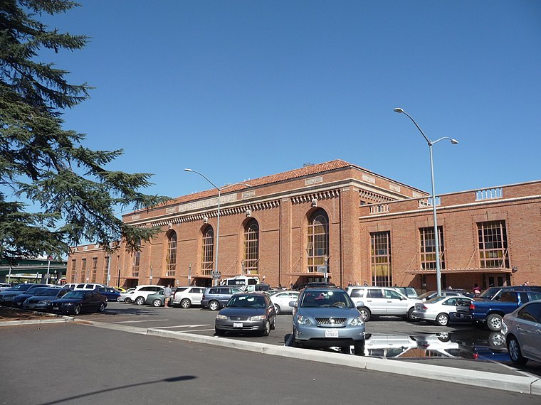
Photo: Randwick, CC BY-SA 4.0.
Sacramento Valley Station is an Amtrak railway station in the city of Sacramento, California, at 401 I Street on the corner of Fifth Street, built in 1926 on the site of China Slough. Sacramento Valley Station is situated 1¼ miles south of Redbud.
7th & Richards/Township 9 station
Railway station
7th & Richards/Township 9 station is a side platformed SacRT light rail station in Sacramento, California, United States. The station was opened on June 15, 2012, and is operated by the Sacramento Regional Transit District. 7th & Richards/Township 9 station is situated 1 mile southeast of Redbud.
Places in the Area
Nearby places include Sacramento and Gardenland.
Sacramento
 Sacramento is the state capital of California in the United States. It is the regional center for the Greater Sacramento metropolitan area, which dominates much of the surrounding Sacramento Valley and stretches into parts of Gold Country.
Gardenland
Hamlet
Gardenland is a neighborhood in the city of Sacramento, California, around the Natomas Basin. It borders Northgate Boulevard to the west, Indiana Avenue to the north, Steelhead Creek to the east, and the Arden-Garden Connector to the south. Gardenland is situated 2 miles east of Redbud.
West Sacramento

Photo: Wikimedia, Public domain.
West Sacramento is a city of 54,000 people in Yolo County in the Sacramento Valley of California. West Sacramento is on the west bank of the Sacramento River, opposite the city of Sacramento.
Redbud
- Type: Picnic site
- Category: tourism
- Location: Sacramento County, Sacramento Valley, California, United States, North America
- View on OpenStreetMap
Latitude
38.60305° or 38° 36′ 11″ northLongitude
-121.50579° or 121° 30′ 21″ westOpen location code
84CWJF3V+6MOpenStreetMap ID
node 2528281475OpenStreetMap feature
tourism=picnic_site
This page is based on OpenStreetMap, Wikidata, and Wikimedia Commons.
We’d love your help improving our open data sources. Thank you for contributing.
Satellite Map
Discover Redbud from above in high-definition satellite imagery.
Places with the Same Name
Discover other places named “Redbud”.
Notable Places Nearby
Highlights include Discovery Park and Tiscornia Park.
Nearby Places
Explore places such as Sycamore and Alder.
Sacramento County: Must-Visit Destinations
Delve into Sacramento, Elk Grove, Folsom, and Citrus Heights.
Curious Picnic Sites to Discover
Uncover intriguing picnic sites from every corner of the globe.
About Mapcarta. Data © OpenStreetMap contributors and available under the Open Database License". Text is available under the CC BY-SA 4.0 license, except for photos, directions, and the map. Photo: J.smith, CC BY-SA 3.0.