Kiipeilyseinämä Harju
Kiipeilyseinämä Harju is a sports venue in Kouvola, Kymenlaakso. Kiipeilyseinämä Harju is situated nearby to the peak Petkelmäki, as well as near the islet Lammassaari.| Tap on a place to explore it |
Places of Interest Nearby
Highlights include Kuusankoski plant and UPM Kymi.
Kuusankoski plant
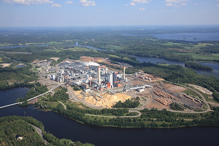
Power station
 Kuusankoski plant is a power station, which is situated 3 km west of Kiipeilyseinämä Harju.
Places in the Area
Nearby places include Kuusankoski and Tehola.
Kuusankoski
Town

Photo: Niera, CC BY-SA 3.0.
Kuusankoski is a neighbourhood of city of Kouvola, former industrial town and municipality of Finland, located in the region of Kymenlaakso in the province of Southern Finland. Kuusankoski is situated 4½ km west of Kiipeilyseinämä Harju.
Tehola
Neighborhood

Photo: Nimimerkki951, CC BY-SA 4.0.
Tehola is a neighborhood, which is situated 5 km southeast of Kiipeilyseinämä Harju.
Valkeala
Town

Photo: Masseja, Public domain.
Valkeala is a former municipality of Finland. It is located in the province of Southern Finland, and is a neighborhood of city of Kouvola, and it was a part of the Kymenlaakso region. Valkeala is situated 6 km northeast of Kiipeilyseinämä Harju.
Kiipeilyseinämä Harju
- Type: Sports venue
- Categories: climbing site, recreation area, and sports location
- Location: Kouvola, Kouvola, Kymenlaakso, Southern Finland, Finland, Nordic countries, Europe
- View on OpenStreetMap
Latitude
60.90902° or 60° 54′ 33″ northLongitude
26.70664° or 26° 42′ 24″ eastElevation
8 metres (26 feet)Open location code
9GG8WP54+JMOpenStreetMap ID
node 2562604048OpenStreetMap feature
leisure=sports_centreOpenStreetMap feature
sport=climbing
This page is based on OpenStreetMap, Wikidata, and Wikimedia Commons.
We’d love your help improving our open data sources. Thank you for contributing.
Satellite Map
Discover Kiipeilyseinämä Harju from above in high-definition satellite imagery.
Notable Places Nearby
Highlights include Petkelmäki and Lammassaari.
Nearby Places
Explore places such as Lappakoskentie-Miehontie th I and Lappakoskentie-Miehontie th L.
Kymenlaakso: Must-Visit Destinations
Delve into Kotka, Hamina, Miehikkälä, and Pyhtää.
Curious Sports Venues to Discover
Uncover intriguing sports venues from every corner of the globe.
About Mapcarta. Data © OpenStreetMap contributors and available under the Open Database License". Text is available under the CC BY-SA 4.0 license, except for photos, directions, and the map. Photo: Junafani, CC BY-SA 3.0.